
J.I. Garver,
Geology Department, Union College
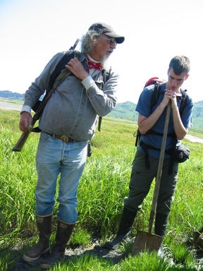
The shovel slid easily into the muck, and with a little persistence in overcoming suction, the distinctive alternating layers of sand and peat are revealed in a shovel full of smelly sediment. We’re on Kodiak Island on the Pacific coast of Alaska and we just hit tectonic gold. We’re digging in tsunami deposits, and the students are transfixed by our host, Gary Carver, a Kodiak resident who specializes in understanding how active tectonic movements affect people and places. He lives in an ideal spot to practice his profession.
Alaska is a rough, wild, and remote tectonic playground: we could think of no better place to teach students the basics of doing fieldwork related to geological hazards. Part of what makes Alaska distinctive is the major fault lines and the rumpled mountain ranges driven by the ongoing collision of the tectonic plates. Like Washington and Oregon in the Pacific Northwest, Alaska sits on a subduction zone where oceanic plates are forced below the continental edge and the resulting volcanoes define dramatic topography. Like the San Andreas in California, Alaska also has a major fault line where two plates slide past one another. So, in a sense, Alaska has the distinction of facing tectonic shakeups like nowhere else in North America. That’s why we decided to take students there, so we could see why Alaska is at the North American tectonic frontier.
Living on the Edge is a mini-term focused on geologic hazards where plates collide. Together earthquakes, floods, volcanoes, and even hurricanes account for some of the most dramatic hazards that humans face, and it is not uncommon for these terrifying events to lead the annual list of catastrophic loss of life. As often as big events occur, we are still learning some tough lessons that don’t seem that complicated. Hurricane Katrina was a pretty good example. So was the Sumatran earthquake and subsequent tsunami in December 2004. This latter event was a humbling example of how major earthquakes that rupture the ocean bottom can generate monstrous tsunami waves that travel around the world and do a considerable amount of damage in the process.
The odd thing is that we have the scientific knowledge to tackle many of these problems, and we have engineering solutions for warning systems, and safe designs for buildings, bridges, and other infrastructure. But if this is the case, why do we seem to get caught off guard so often? Sometimes we don’t and we get it right, and this is part of why we wanted to visit Alaska.
Alaska has had its fair share of shakeups and volcanic eruptions. In 1964, Alaska was shaken by the second biggest earthquakes ever recorded by humans: magnitude 9.2. This event resulted in some of the most dramatic tectonic movements the modern world has ever experienced. Like the Sumatran earthquake of 2004, a huge block of ocean floor was displaced upwards, and the movement displaced enough water to spread tsunami waves around the globe. One of the most fascinating aspects of the 1964 quake in Alaska is that large swaths of land moved upward (uplift) and land in a nearly equal area went downward (subsidence). Part of our task on this miniterm is to understand clues to these tectonic undulations.
Discussing tsunami deposits in Middle Bay, Kodiak Island. Kodiak Geologist Gary Carver and student John Campano (Geology, 2009) have the proper tools for the job: a shovel and a 12-gauge shotgun (Photo: J.I. Garver).

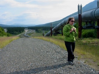

Amanda Kern (Geology and Environmental Studies major) looked into the environmental effects of the Trans Alaskan Pipeline before the trip. Here she gives the group an overview of the pipeline in the Central Alaska Range where it crosses the Denali Fault zone (Photo: J.I. Garver)
Blogging Across Alaska. Part of our agenda for the trip was to get students back to nature. This meant getting students to hike, camp, cook on a fire, and get their wet feet, literally. For many students on the trip, this was the first major experience away from home. For almost all of them, it was the first extended time in tents away from modern conveniences, such as showers and the internet. And for some, just the trip to Alaska was notable because it was the first time they’d ever flown in a plane. So how do we connect these traditional outdoor experiences with a cohort of students so accustomed to living in an electronic cocoon? Co-leader of the trip, Professor Jacyln Cockburn set up a Blog (an ongoing web-based collection of ideas) that allowed posting of commentary and photos of the trip. This was a brilliant idea that allowed an “old school” outdoor experience to dynamically mesh with the temporarily abandoned electronic cocoon. Although a great idea, we soon found that Wi-Fi hot spots are less common in Alaska than in New York. However, we did eventually sort out our connectivity problems. Parents, friends, and others followed our progress, some perhaps a little nervously. Through the course of the excursion, students wrote entries that reflected their experiences, thoughts, and impressions. The response was amazing and a number of parents noted that they waited for each new entry to be posted. For a few who watched the trip from afar, the blog relieved anxiety because they could see how the trip was unfolding, but the most important result is that the blog connected parents to the learning process.


© Geology Department, Union College, Schenectady N.Y. 12308. All rights reserved. No part of the document can be copied and/or redistributed, electronically or otherwise, without written permission from J.I. Garver, Geology Department, Union College, Schenectady NY, 12308-2311, USA.
August 2007