Schenectady County Geology
Union College Geology Department
| HOME |
Geology of Wolf Hollow, Schenectady County, NY J.I. Garver, Geology Department, Union College. |
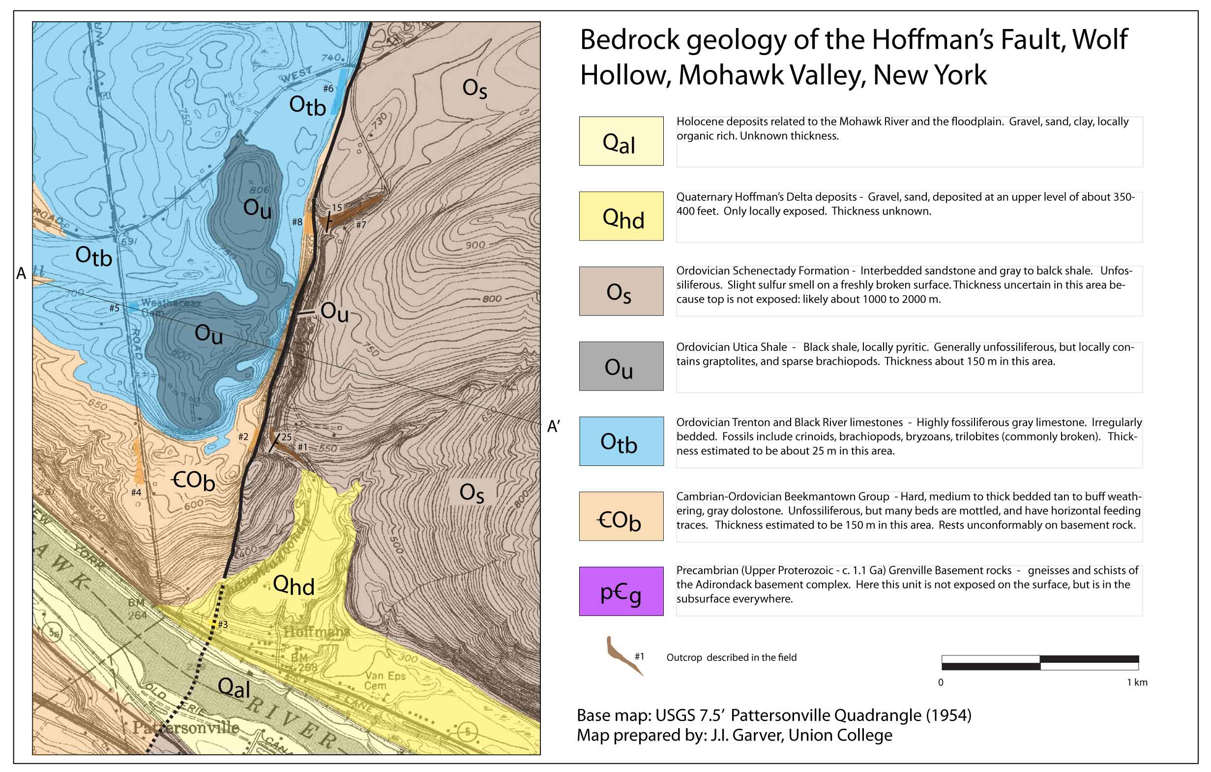
Wolf Hollow is a narrow, confined section of Chaughtanoonda Creek in western Schenectady County, NY. The Hollow has developed along the Hoffman's fault largely through differential erosion facilitated by weak rock along the fault as well as the juxtaposition of different rock types. Wolf Hollow is one of many deeply incised small tributaries to the lower reaches of the Mohawk River (Cranes Hollow and the Plotterkill are good examples that are very close to Wolf Hollow), that have developed due to focussed erosion resulting from incision and a drop in base level of the Mohawk. Although these other tributaries are steep and narrow, they are not occupied by normal faults. Very different rock types are juxtaposed along the fault. In the Hollow, the east side is underlain by interbedded sandstone and shale of the middle Ordovician Schenectady Formation (c. 450 Ma), a deep basin deposit that accumulated during the Taconic orogeny when the Taconic Arc collided into the edge of North America. The Schenectady Formation is very well exposed in the Hollow, and in fact all of the exposed bedrock in the road cuts is this unit. The interbeds of light brown sandstone and gray-black shale give the rocks a distinctive appearance. On the west side of the fault are stratigraphically lower strata. These strata include the Utica Shale (only on the hilltops), limestones of the Trenton Group (light gray and incredibly fossiliferous), and the very thick and extensive brown-gray dolostones of the Beekmantown Group. The rocks visible on the west side of the Hollow are the prominent cliff-like exposures of the Cambrain and Ordovician Beekmantown Group (c. 500 Ma). These carbonate rocks span the Upper Cambrian and the Lower Ordovician periods and they represent a time when this area was covered by a warm tropical sea and the shallow shelf would have been a lot like the coast of southern Florida, or the Bahamas today (both limestone and dolostone are types of carbonate, dolostone is a bit more resistant to weathering than limestone). Despite these favorable conditions, there are very few fossils preserved in these dolostones. The most common evidence of life in these rocks are the locally abundant trace fossils, which are mainly tracks and trails best seen in horizontal bedding planes in the rocks.
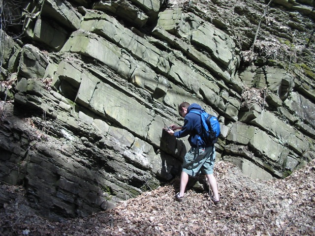
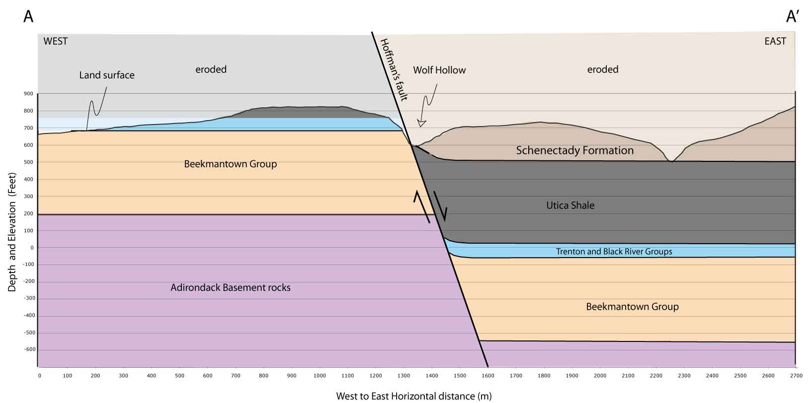
Student measuring the tilt of the middle Ordovician Schenectady Formation in the hangingwall of the Hoffmans Fault, Wolf Hollow (NY). (J.I. Garver). Geologists know the general thickness of the strata in this area, so by matching layers on either side of the fault they have been able to estimate the apparent offset of the layers. This estimate is between about 200 to 350 m (about 650 to 1100 feet), which is based on a crucial assumption about the position of the contact between the very thick and extensive Schenectady Formation and the underlying Utica Shale. The fault can be traced north into the Adirondacks. To the south it is difficult to trace and it does not appear to cut any younger overlying rocks in the Helderbergs. The fault itself is not exposed in the Hollow, but instead is covered by debris and soil. This is not uncommon because fault zones commonly are zones of weak, ground up rock, so after some erosion, they tend to be low areas that get filled in. We know that the fault is a near vertical plane that is slightly inclined to the east, estimates are between about 60° and 80°. With this fault inclination, and this sort of strata offset, we know that the Hoffman's fault is a Normal Fault. The east side is what geologists call the hanging-wall, and the west side is the footwall. The east side has dropped down, relative to the west side. In the Wolf Hollow area, we mainly see hard resistant dolostone to the west (Beekmantown Gorup) and relatively weak shale and sandstone of the Schenectady Formation to the east: this hard rock/soft rock juxtaposition means that there is a slight topographic expression of the position of the fault because the hard carbonate rocks are slightly higher. Using this relationship, the trace of the fault can be estimated to the northeast as it leaves Wolf Hollow, which is clearly seen on topographic maps.
Geologic map Hoffman's fault, western Schenectady County. The northeast-trending Hoffman's fault belongs to a family of near parallel faults in the lower Mohawk valley that cut Ordovician and older rocks. The faults tend to die out or are covered by Silurian and younger strata to the south below the Helderberg escarpment. This regional relationship is one on the main reasons that geologists suspect that fault movement occurred in the Ordovician period, about 450 Million years ago. Therefore geologists infer that the faults were formed during the Taconic orogeny when this area was a basin that was locally breaking: all of the activity was driven by the collision of the Taconic Arc. A number of these northeast-trending faults cut what we call "basement" rock of the Adirondacks, and in fact these structures give the Adirondacks some of their distinctive topographic grain. A number of NE-trending lakes are formed by differential erosion along these faults. Perhaps the most dramatic is Lake George, which has a fault on either side and the block in the middle (now the lake), dropped down.
What is most important to bear in mind is that geologists agree that that fault is not currently active, and in fact it probably hasn't moved in millions of years. So, this fault should have no bearing on the seismic hazards in this area. As discussed above, most agree that slip on this fault occurred in the middle Ordovician, when the basin formed that filled with the Schenectady Formation during collision of the Taconic Arc. However, later slip related to Acadian tectonics, or even the opening of the Atlantic, cannot be ruled out and remains an important outstanding research problem. Wolf Hollow is occupied by a Schenectady County Road, but the surrounding land is entirely private. There are several pull offs along the road, and the best way to see the Hollow is to park and walk along the road edge. In July 2008 locally heavy rains caused a tremendous amount of erosion, and the road was closed for several months. |
This document can be located from http://minerva.union.edu/garverj/mohawk/
© Geology Department, Union College, Schenectady N.Y. 12308-3107. All rights reserved. No part of the document can be copied and/or redistributed, electronically or otherwise, without written permission from the: Chair, Geology Department, Union College, Schenectady NY, 12308-2311, USA.