Major Floods on the Mohawk River (NY): 1832-2000
Mat Scheller
Karen Luey
John I. Garver, Ph.D.
Geology Department
Union College
Schenectady NY 12308 (USA)
(518)-388-6517
Version 1.2
March 2008
ABSTRACT
This report provides a brief historical account of flooding on the eastern section of the Mohawk River for the last 170 yr, to gage the impact of human development and the impact of flooding on settlements along the river. This historical record was constructed through detailed examination of newspaper accounts, and other historical docments. Flooding of the Mohawk River is associated with two main types, "Free water" flood events and "break-up" events. "Free-water" flood events commonly occur in late summer and early fall, during the peak of hurricane season and are associated with large amounts of precipitation. Break-up events are associated with the break-up of river ice, resulting from rising temperatures, melting snow, and heavy rains and commonly occur during winter and early spring. Break-up events are exacerbated by the formation of ice jams and account for the majority of the large scale flooding events (< 15’). The worst flooding occurred in the late 1800’s and early 1900’s, where stages >15’ were reached eight different times in a span of 45 years. This time span concluded with the great Flood of 1914, the most devastating event in recorded history. Since the 1914 event, there has been a decline in the frequency and magnitude of flooding in the Schenectady region.
_____________________________________________
INTRODUCTION
Purpose and Scope
The Mohawk River has been an integral part in the development and history of New York. Located in Upstate New York, the Mohawk River, the major tributary of the Hudson River, and it drains about 3456 square miles. Historically, it has been a hub for transportation and trade by the Native American tribes, mainly the Mohawks and Iroquois (Gara, 1999). Its floodplain was prized for its fertile ground. It was a means of transportation to other cities and outlying areas, as well as a source of energy for mills and manufacturing. The Mohawk River has been transformed during the last 200 years to meet the needs of a developing society. Today, we have modified the river extensively: locks, dams, canals, and bridges have effected the flow of the river, along with development along the riverbanks.
The purpose of this report is to provide a historical account of flooding on the eastern section of the Mohawk River for the past 170 years, to gage the frequency and occurrence of major floods on the local residents. Additionally, we are interested in assessing the impact of human development on floods and and the impact of flooding on humans. This historical account of flooding is used to determine problematic sections of the river and the effect of the construction of dams, locks, and bridges on flooding. The goal of this report is to determine timing and magnitude of historical floods, the cause and impact points of floods, as well as to determine whether the severity and frequency of flooding have increased in the past two centuries. By assembling this historical record, we will be able to determine whether the construction of dams and locks has increased the severity of floods along the eastern stretch of the Mohawk River, as well as to determine whether there has been an increase in storminess associated with global warming. Future studies will hopefully be able to tie this historical record of flooding to the longer record, which is preserved in floodplain sediments.
Previous Work
Little has been assembled on the modern (post 1800) flooding of the Mohawk River in the Schenectady area. In 1977, the Schenectady Chamber of Commerce created "A Chronology of Floods and Flood Related Events in the Schenectady Section of the Mohawk River", which was researched and written by M. Van Bogert. This report identified the dates of the construction of locks and dams along the Mohawk, as well as the dates of major floods, which affected the Schenectady.
Understanding the chronology of flooding on the Mohawk River has been a research focus of J.I. Garver in the Geology Department (Union College) since 1996. The general history and geologic evolution of the Mohawk River was researched by J.J.Gara in "Bridging the Mohawk" and "The Historical Record of Flooding on the Mohawk River, New York". Jason Lederer and J.I. Garver recently completed "Ice Jams during the 1996 Mid-winter flood of the Mohawk". This report is a reconstruction of ice jams locations based on tree scars along the Mohawk River to determine the location of obstructions which caused ice jams (see web links at the end of this report).
This document which outlines major floods on the Mohawk River in the Schenectady region was researched in two parts. The time between 1832 to 1903 was investigated by Karen Luey, and the time between 1904 and 2000 was researched by Mat Scheller. Mat put the document together and wrote the introductory remarks. The majority of historical documentation is available from the Schenectady Historical Society. Funding for certain aspects of this project was provided by the National Science Foundation.
Topography and Drainage
The area described in this report encompasses the entire drainage basin of the Mohawk River and its tributaries, but the main focus of the report is the flooding within Schenectady, Scotia, Rotterdam, Rexford, and Niskayuana. Flooding of the Mohawk upstream and in the tributaries are discussed due to their importance in causing or increasing the severity of flooding downstream in the Schenectady Region.
The eastern section of the Mohawk River lies in a relatively low-lying area. Schenectady sits on the part of the river where there is a major decrease in gradient and in late glacial times this was the site of the "Scotia delta" built by the Mohawk as it flowed into Glacial Lake Albany (Gara, 1999). The Adirondack Mountains bound the Mohawk River to the north, the Taconic Mountains to the east, and the Helderberg Escarpment to the south. The Mohawk River generally flows to the east-southeast within this area. The western part of this section contains the upland area comprised of till covered bedrock hills. This area from Hoffmans to Scotia contains steep valley walls with high relief associated with the high surrounding hills and the incision of the Mohawk in to the glacial till and bedrock of the Schenectady Formation. The altitude of the uplands range from 800 to 1,300 feet above sea level. The lowland area of the Mohawk Valley extends from the Scotia Delta to the outflow of the Mohawk into the Hudson River. This area is bound by the upland and has an average altitude of 350 feet above sea level. The majority of the lowlands consist of till covered bedrock and lake sediment.
The major tributaries of the Mohawk River enter in the western section of the Mohawk. West Canada Creek drains the Hinkley Reservoir, built in 1914 and flows into the Mohawk to the west of Little Falls. The other major tributary is the Schoharie Creek, which drains north from the Schoharie Reservoir, built in 1926. Smaller tributaries in the area of concern are Alplaus Kill, Lisha Kill, Plotter Kill, and Poentic Kill. The Plotter Kill and the Poentic Kill drain the upland area between Hoffmans and Scotia. The Alplaus Kill drains the hilly region and the lake plain in Glenville. The Lisha Kill drains the lake plain area of Albany County (Winslow, 1965).
Climate
The Mohawk Valley drainage basin is located in upstate New York between the Adirondack Mountains to the north and the Catskill Mountains to the south. Its location in the middle latitudes on the East Coast of the North American Continent is the major determining factor in weather patterns that affect the area. The climate of New York is the humid continental type; cool dry airmasses generally move eastward through the state throughout the year, and warm, humid, maritime tropical airmasses from the south move northeastward during the summer (Lumia, 1998). New York is predominately affected by north and south temperature variation. To the north lies Canada, where cold, dry Arctic airmasses are formed. To the south, the Gulf of Mexico and the Atlantic Ocean carry warm moisture rich tropical airmasses. The drainage basin lies in an area between the two predominate weather patterns from the west and south, with occasional storms, which travel to the northeast. Large-scale frontal systems, small-scale convective storms, and hurricanes and cyclones also affect the drainage basin. The large-scale frontal systems generally travel eastward across the state carrying lake-effect moisture during the winter months (Paulson, 1998). These frontal systems intensify as they travel into the Atlantic and tend to produce secondary storms, which form Nor’Easters. Tropical airmasses moving from the south generally affect this area during the summer months (especially between September through November), where they attain the strongest northward advance with the absence of cold fronts to the north. These small-scale convective storms produce the majority of precipitation during these months. The amount of annual precipitation differs widely throughout the state due to differences in topography, relief, and water surfaces. The Mohawk drainage basin generally receives its largest amount of precipitation from the southwest slopes of the Adirondack and Catskill Mountains, where approximately 55" of rain fall annually. The Schenectady region generally receives about 35" per year (Paulson, 1998).
Geology
The bedrock of the Mohawk Valley drainage basin is comprised of Cambrian-Ordovician rocks, but the Catskills (Schoharie Tributary) is underlain by Devonian clastic, sedimentary rocks. The carbonate rocks of the Lower Beekmantown Group are the oldest, deposited in a shallow marine environment during the Cambro-Ordovician. The Lower Beekmantown Group consists of the Potsdam Formation and the Galway Formation. The Upper Beekmantown Group contains carbonate rocks of the Tribes Hill Formation and the Chucanunda Creek Dolostone. Overlying the Chucanunda Creek Dolostone are the fossiliferous limestone of the Black River Group and the Trenton Group, which were deposited in a shallow marine environment during the Middle to Late Ordovician. Stratigraphically above the limestones of the Trenton Group lies the Utica Shale of the Trenton Group, a black-, fossiliferous shale, deposited in a near to deep-marine environment. The Utica Shale thickens to the west. The interbedded sandstone and shale of the Schenectady Formation overlies the Utica Shale. The Schenectady Formation is the prominent formation within the region examined in this report. The Mohawk River within the Schenectady Region has incised through the Schenectady Formation, leaving many outcrops-lined gorges, such as the narrows downstream of Rexford Bridge.
The formations underlying the Mohawk River were deposited during the Cambrian and Ordovician age. During the Ordovician, the Taconic Island Arc began to Collide with the North American Plate, producing a flexural basin. Erosion of the Island Arc produced large amounts of sediment, which was deposited in the deepening marine environment. As the flexural basin was closed by the continuing collision of the Arc, a thrust belt system was produced, causing large and small-scale deformation of the Schenectady Formation. The deformation can be observed along the banks of the Mohawk at Visher Ferry.
The evolution of the Mohawk Valley was primarily due to continental glaciers, which advance at least four times during the Pleistocene Epoch, covering this region with at least a kilometer of ice. With the retreat of the of glaciers, a lobe to the west of the Adirondack Mountains produce large amounts of melt water, creating the massive Lake Iroquois. The lake drained in a southeast direction, through the Mohawk Valley. The melt water from Lake Iroquois emptied in to Lake Albany, a lake produced from the retreat of the lobe in the Champlain Hudson Valley. Due to a terminal moraine in the vicinity of New Burgh, New York the level of Lake Albany continued to rise, extending to the Schenectady Region. Sediment carried from Lake Iroquois created a delta at Scotia and covered the majority of the Schenectady Region with glacial and lake sediment. As Lake Albany began to drain, the Mohawk needed to decrease its sinuosity. The result was the avulsion from the Iromohawk Channel to the present day course of the river (LaFleur, 1995).
History on the River
The Mohawk River directed and influenced the settlement of Upstate New York. The river was vital component in the lives of the Native Americans tribes, providing a means of travel, trade, and fertile low-lying areas for farming. Trade brought European settlers to this area and the development of the river blossomed. As Upstate New York became increasingly populated, the need for efficient means of transportation became vital, spawning the construction of bridges, dams, and canals. Thus began the war between the Mohawk River and the construction of structures essential for the development of Upstate New York.
The first successful bridging of the Mohawk occurred in 1795 with the completion of a wooden bridge built on stone pillars between Cohoes and Waterford. In 1806, the Alexander Bridge was built, connecting the Ballston Turnpike, but that same year the bridge was washed out by the river’s torrent. After many thwarted attempts, the Burr Bridge was finally completed in 1808. As a result of the long distance, which the bridge spanned, four piers were added in 1821. In 1825, the Rexford Bridge and the aqueduct were constructed. As railroad became the preferred means of transportation, the Saratoga and Schenectady Railroad built tracks on the Burr Bridge in 1832. In 1835, the Saratoga-Schenectady Railroad Bridge was constructed a half-mile downstream of the Burr Bridge. In 1850, the need from pedestrian transportation across the river, northeast of Schenectady rendered the construction of the Rexford Bridge, upstream from the Rexford Aqueduct (Gara, 1999). With the Burr Bridge becoming increasingly unstable, Freeman’s Bridge was built a mile downstream from the Burr Bridge in 1855. The Burr Bridge was dismantled and replaced with an iron bridge between 1871 and 1874. The new bridge is commonly referred to as the Glenville Bridge, the Scotia Bridge, and the Washington Avenue Bridge. The Visher Ferry Bridge was constructed in 1898, only to be washed away in 1902. The end piers remain in place. The flood of 1914 destroyed the majority of the bridges in the area, sparing the Burr Bridge (Van Bogert, 1977). Freeman’s Bridge was the first to be rebuilt in 1917, followed by the Western Gateway Bridge in 1924. Both structures were redesigned to accommodate modifications in the new canal system. The Western Gateway Bridge replaced the Burr Bridge, which was becoming hazardous to traffic. The Burr Bridge was removed in 1939, but the piers were not removed until 1947. The end piers still exist today.
The construction of the Erie Canal began in 1817, raising the height of the Mohawk to 228.8 feet above sea level from Lock 27, west of Schenectady (Van Bogart, 1977). The construction of the Erie Canal was completed in 1825, linking Lake Ontario to New York City. The canal was 40’ wide by 4’ deep, with towpaths along each side (Gara, 1999). The canal paralleled the Mohawk River and criss-crossed the river with the use of aqueducts. The need for more efficient means of travel brought the enlargement of the Erie Canal, which commenced in 1835. The enlargement program was completed in 1862, widening the canal by 30’, deepening it by 5’, and doubling of many locks (Gara, 1999).
The establishment of the of the Modern Lock System with in the Schenectady area commenced in 1916. The destruction of most bridges during the flood of 1914 allowed the new barge canal to be situated in the main canal of the Mohawk River. The 22 locks system of the Erie Canal was replaced by a series of dams and locks, which transformed the river into a flat-water canal. The Visher Ferry Dam and the Crescent Dam were completed in 1914 and 1915, respectively. The new barge canal contained 16 locks, raising the river level to 211’ above sea level. In 1922, 2’ flashboards were installed on the Visher Ferry Dam, raising the river to its present elevation of 213’ (above mean).
Flooding Types
Flooding on the Mohawk River is associated with two main types of events; "Free-water" flood events and "breakup" flood events. All flooding results from significant amounts of precipitation, but the type of flood event is generally determined by the influence of river ice.
One type of flood event is the "Free-water" floods which mainly occur during the autumn. The major cause of the "Free-water" events is tropical depressions, which supply significant amounts of precipitation. These floods typically occur during the peak of the hurricane season (September-November). Flooding generally occurs as hurricanes and tropical depressions travel northward from the Gulf of Mexico and brush the eastern coast of North America. Local intense thunderstorms also spawn flooding during the early summer to early fall, although the outcome of flooding is minimal. The "Free-water" events are produced by heavy amounts of precipitation, but generally the extent of flooding is relatively small.
The other type of flooding is associated with winter and spring break-up events. These events are commonly associated with the occurrence of ice floes and ice jams. The break-ups are characteristic of freezing temperatures in prior months. During this period of freezing temperatures, the ground surface is covered with an accumulation of snow cover, the ground is frozen to a depth dependent on the presence of snow cover, and the depth of river ice increases. With the onset of rising temperatures, the snow mantle begins to be released, but the existence of frost prevents the absorption into the ground (Hoyt, 1955). These events are almost always accompanied with snow and heavy rains, resulting from large-scale frontal systems or Nor’Easters.
Rising temperatures melt the winters snowpack, coupled with large amounts of precipitation causing large quantities of runoff. Breakup events occur as melt waters percolate in cracks in the river’s ice, transforming it from solid ice to a honeycomb structure (Hoyt, 1955). As the river swells, ice is broken from its banks and begins to flow. Ice dams occur when the ice floes become lodged on obstruction within the river, usually at narrow points along the river, bridge abutments, or other obstacles in the flood plain. When dams begin to form, ice continues to accumulate on the jam and the water behind the jams begins to rise. The rise behind the jams often occurs at spectacular rates, causing the flooding of upstream areas. The pressure of the retained waters ruptures the dams, causing an immense surge of water downstream. Break-up events commonly occur yearly, but the extent of flooding is dependent on ice thickness, snow depth, and amount of precipitation.
METHODS
This historical record of flooding on the Mohawk was constructed through a detailed examination of newspaper accounts. The dates of flooding since 1917 were determined by water flow data from the U. S. Geological Survey monitoring at Cohoes, NY. Dates of high daily mean flows and crest flows were identified as possible dates of flooding. Dates of flooding prior to 1917 were determined through historical research at the Schenectady Historical Society, as well as from previous work done on flooding in the Schenectady Region.
Once dates of flooding were identified, detailed examination of newspaper accounts were completed, focusing on human impact, cause of flooding, and observed occurrence of ice jams. The analysis of each flood began with a general description of flooding, the type of flood, as well as the cause and impact. For floods occurring after the completion of the Cohoes monitoring station in 1917, the peak and mean discharge rates for the event were recorded. For floods occurring prior to monitoring, general observations of discharge were noted, including determining stage height by known landmarks, especially bridges. The stage in Schenectady to which the waters reached was described if known. If ice jams occurred during the flood event, the thickness prior to the breakup, the location of the jams, the longevity of jamming, and the rate of rise behind the jam were recorded.
One of the most important aspects for providing a historical record of flooding is the weather, which produced the flooding. The type of storm which produced the precipitation was first determined (i.e. Nor’Easter, Hurricane, or simple thaw). For winter floods and spring breakups, the rate of temperature rise and the snow or rain equivalent were determined. If flooding resulted from a hurricane, the storm track and the total rainfall distribution were determined. Note, however, that in general accurate weather summaries are difficult to glean from newspaper accounts prior to about 1950.
The amount and location of flood damage is as important as the cause of the flood event. This historical record also indicates the common areas affected by the flooding. Through the examination of newspapers and historical documents, the areas impacted and inundated by the flood events were determined. This record allows us to determine frequently impacted areas.
FLOOD EVENTS ON THE MOHAWK
"1832: Unprecedented in the recollection of our oldest citizens." (1)
Year: 1832
Date: 13 March
Type: Spring Breakup
Cause: Thaw and Rain
Ice Jam: Upriver of Burr Bridge
Peak Discharge: not known
Mean Discharge: not known
Stage in Schenectady: not knownIn the spring of 1832, a breakup occurred which was brought about by a rapid rise in the water level. The pathway of this inundation is similar only to the ice-related flood of 1893. Ice jammed upriver from the Mohawk Bridge (i.e. Burr Bridge). Water behind the jam found its way to the canal above the city and then broke through the canal banks in several spots, flooding the south side of Schenectady. No landmarks were included in the newspaper articles to indicate water levels, or the rate of flow.
Accounts of the flood suggest the water rose very quickly in the middle of the night. An alarm bell was rung at 2:00 AM to warn citizens to evacuate, we suggest that crest occurred sometime after, probably at night but we have no data to confirm this. A dramatic account was included which detailed night evacuation by boat in the rising water. A boat was secured to rescue some women and children that were trapped in a partially demolished house. As the boat was carrying them to safety, it sank and chaos followed.
"The scene of confusion was truly awful the shrieks of the women,
and cries of the children, together with the roaring of the water and
the shouts of the men urging one another to assist the unfortunate,
made the bye-standers horror struck." (1)Although no one was lost in this particular mishap, another man lost two of his small children to the rising floodwaters. His account of the flood was contained in the Schenectady Cabinet the following week.
Later accounts suggest that the waters rose so rapidly that a trapper by the name of Louis J. Barnhydt, who was setting traps in the river, had to climb a tree to escape the inundation. He was rescued with "great difficulty" (20). Note that this article (written some 50 years later) inaccurately indicates that the river was free of ice, and the flood was not related to an ice jam: accounts in 1832 clearly indicate this flood was accompanied by ice jams. *
As the sun came up following the flood, "As far as the eye could reach, a broad sheet of water presented itself, bringing along with it the effects of its ruin fences, sheds, trees, and huge masses of ice." (1) Some individuals lost everything they owned; one person listed his losses at $1500 to $2000. Several boats were carried off in the waters and there was damage done to both the Erie Canal and the railroad across the flats.*
*We cannot verify this story from the 1832 accounts and it is not clear if Barhydt was setting traps at night or whether he was caught in high water before or after the night time crest.
"1853: Minor Flood"
Year: 1853
Date: 18 September
Type: Autumn Flood
Cause: Tropical Depression
Peak Discharge: not known
Mean Discharge: not known
Stage in Schenectady: 5’ above normalWe are not certain if this is a significant flood. Accounts of the much later1869 flood indicated that the 69 flood was the "highest the water has been in sixteen years" thereby suggesting a flood in 1853(10). In this 1869 news account, no specific reference was made to the exact date of the 1853 flood therefore the entire year of newspapers were examined. No clear event is evident from this survey, and for this reason the collection of accounts from three different time periods of the year are given here. It is likely that the flood refers to an event in September. In February, there is a short paragraph in the weekly publication pertaining to the breakup of the ice due to mild weather. No follow up in later papers indicated that a flood was part of this situation. All indications pointed to a normal spring thaw. If anything, it seemed it was an update on the ice in the river, advising travelers not to go out on the ice. "The ice had been sufficiently strong got teams to cross only for ten days previous." (3)
In May a short paragraph cites a break in the canal that occurred on the previous Friday. No mention is made regarding how the break occurred. The nonchalance of the information indicates normal spring thaw. (4) Due to the scant coverage in the September Cabinet, it seems appropriate to include the entire article: The heavy rain on Saturday evening caused a sudden rise in the Mohawk and its tributaries. On Sunday evening the water in the Mohawk was five feet above its ordinary level, and large quantities of wood drifted down. Several bridges on the Mohawk turnpike were carried away. An earth-slide on the railroad tracks in Schermerhorns ravine caused a detention of the cars for a few hours. Veeders milldam, we understand, was partially damaged. A rain gauge showed a fall of two and a half inches of water. (5)
Clearly this flood didn’t reach the levels of others in our study window. It is possible that this year was referred to in error by later news accounts years later. According to one hurricane record, a hurricane did occur in the western Atlantic between September 6-7 causing 40 deaths (Rappaport and Fernandez-Partagas). It is possible that the low pressure system took 10 days to then go up to New York.
"1865: Civil War Flood"
Year: 1865
Date: 16 March
Type: Spring Breakup
Cause: Thaw and Rain
Peak Discharge: not known
Mean Discharge: not known
Stage in Schenectady: not knownIn March of 1865, spring breakup caused extensive flooding in eastern New York State including Rochester. Along the Genesee River, a Railroad Bridge was taken out. Along the Mohawk River, telephone poles from Utica and bridges from Fonda, Fultonville, Amsterdam and Schenectady were all carried away. One bridge was floating down the river "accompanied by three canal boats". (7) In Schenectady, the Freemans Bridge was swept away. Although the news accounts give no specific mention of water levels, The New York Times indicates that, below Albany, 8-10 feet of water (Hudson River) submerged docks and piers (8).
"The waterwas not as high at other times, but the great
thickness of the ice, and some canal Boats which floated into
the river near Fort Plain, caused the destruction of these bridges." (9)Grammatically, the first part of this statement is ambiguous, we suspect that it was not the depth of the water but the thickness of the ice that caused the damages, therefore this was not the highest flood the area had experienced.
No specific weather patterns are reported in the news accounts, but it is clear that this was a spring breakup flood and that ice caused considerable damage. Also, there is no mention in any of the articles, to a previous flood in the area for a comparison. The widespread damage across the state included that to the Erie Canal, which required a great deal of repair, delaying the spring opening for navigation. Flooding was widespread during this event as the Genesee River in Rochester reached 45,000 to 54,000 cfs. (Foreman, 1933).
Relatively speaking, there is not much information concerning this particular flood. The lack of information may be due, in part, to other news of the day because the civil war was to end in about seven months. Of particular interest, were the day-to-day issues concerning President Lincoln: The New York Times ran the entire text of a speech regarding the end of slavery. (8)
"1869: The greatest freshet ever before known" (22)
Year: 1869
Date: 3 October
Type: Autumn Flood
Cause: Tropical Depression
Peak Discharge: not known
Mean Discharge: not known
Stage in Schenectady: 18’The autumn flood caused by heavy rains in eastern New York was, at the time, inferred to be "the greatest ever before known." A weekly publication includes two accounts that appear to be copies of articles from the Daily Union printed on Monday and Tuesday of that week. The second directly following, and updating the first. An adjacent article makes mention of the poor grape crop that year due to the very cold summer season. The immediate cause of flooding was a downpour that began on Sunday morning (Oct. 3) and continued until 10:00 AM Monday (Oct. 4). The hardest rainfall occurred between 4:00 AM and 9:00 AM (Oct.4), which "Our oldest citizens say, never saw anything before equal the fall of water". The amount of rainfall recorded in Albany (approximately 30 miles to the southeast) was 5.86 inches (10).
The actual depth of the flood stage is poorly known for this event and is only known in comparison to landmarks. For example, water was up to the floor of the Mohawk Bridge (Burr Bridge) and 2 feet of water covered the Scotia Dike. Within Schenectady, College creek (Hans Grootkill) topped its banks and flooded the city streets. Union, Centre, Barrett and Liberty Streets were flooded. At the intersection of Union and Centre (now Broadway) the water was 4 feet deep. As a result of the flood, 300 to 500 cellars were flooded along these streets. Rotterdam Street was also noted as being covered by 4 feet of water. An area known as Veeders Flats was under 6 to 8 feet in many places. Although the level is uncertain it is confirmed in later years at 18 feet (20).
Naturally, the time of year indicates that this flood is not ice related, and it is likely that the rain was generated by a tropical storm. A hurricane hit New England and the Canadian Maritimes, reaching New York on October 3rd (Rappaport and Fernandez-Partagas). New England Hurricanes are relatively uncommon because hurricanes then to lose strength over cooler water. This storm caused 37 deaths. Although this was referred to as the greatest the area had ever seen, a flood six months later (April 1870) would reach a stage about one to two feet higher.
"1870: Spring breakup"
Year: 1870
Date: 18 April
Type: Spring Breakup
Cause: Thaw and Rain
Peak Discharge: not known
Mean Discharge: not known
Stage in Schenectady: 20’Surprisingly enough, the impact of this large flood was scantily documented in the local papers. The competition in the news was the loss of an American ship "The Oneida", presumed sank, which resulted in the loss of many lives. The winter preceding this flood was apparently mild as documented in the news from January to March. Two January publications contain short articles about the failing ice crop for that winter. In late January, the river was still not frozen:
"If cold weather does not set in soon, all hopes of obtaining even half
a crop may be dismissed, for it will require two weeks of steady freezing
weather to make ice, and fully a month to gather it, which would carry
us to March." (12)In early February, "the ethereal mildness generally acknowledged as unprecedented within the memory of the oldest inhabitant." (13) Also quoted in this article is the following entry, which likened this mild river to a similar one in 1718: "In the year 1718, when, on January 15, the ice from the rivers had disappeared and the frost was out of the ground. For three weeks previously the weather had been like spring and peas, beans, & corn had been planted. But a week had scarcely elapsed ere severe cold weather set in, and the rivers were filled with ice." This anecdote about the mild winter of 1718 was included in the article to offer hope for the ice crop.
The April 18 flood of 1870 was due to the combination of rain and snow (14). The rain began on the 18th, however the amount and duration of rainfall is not specifically known. By 3 PM on the 18th the water was 8 feet above low water mark (14). At noon on the 19th, the water had risen to 18.5 feet. This brought the water level up to the floor of the old bridge (Burr Bridge) and at some points covering the planks. The Scotia Dike was under 2.5 feet of water. The Star reported that evening that by 4:00 the water had reached its highest mark of 20 feet and within the hour began receding (17). Later accounts list this flood as "nineteen feet four inches which is believed to be the highest point that the Mohawk has ever reached in this city." (19) One other reference was made to Rotterdam Street in the Union; "The water is now (2 p.m.) about six feet deep in Rotterdam street and all the houses on the street are flooded to the depth of four or five feet on the first floors" (14). The following week reports of damage to the canal included "four large gaps in the tow-path and the canal badly filled with rubbish and stumps" (18).
"1886: The Most Disastrous Flood in the Mohawk Since 1869"
Year: 1886
Date: 13 February
Type: Winter Thaw
Cause: Rain, thaw, and ice jams
Peak Discharge: not known
Mean Discharge: not known
Stage in Schenectady: 17’6"Some sixteen years after the floods in 1869 and 1870, the flood of 1886 was not the highest ever, but the destruction resulting from this flood was extensive. The weather preceding the flood was rainy and warm doubtless contributing to the near instantaneous break up of the ice. We infer that this rise in water occurred in part as a response to ice jamming at the Scotia Bridge. The breaking up began around 3:00 PM, February 13 the flow of the ice slowly started at that point. According to the Daily Union, the gateman at the Glenville Bridge observed the ice on the river: "For a few minutes it glided along so slowly and smoothly as to be almost imperceptible but every moment gathering momentum it was quickly rushing by at race horse speed" (20). This movement of the ice was noted at about 4:00 PM and by 5:00 PM began jamming under the bridges. Because of the jams, the water quickly backed up over the banks of the river. After the event, a survey of the ice floes indicated that the ice jams reached as high as 40 feet and trees on the island were "snapped off like pipe stems by cakes of ice." Measurements of the ice thickness prior to breakup ranged from 18 to 22 inches making the ice blocks in the floe much thicker than normal (19).
The flooding inundated Frog Alley and Rotterdam Street, although no water depth was recorded. The flooding to Frog Alley began once the water level in the river reached 11 feet. At 13 feet the water in Frog Alley was up to the stoops of the houses (19). Water covered the Scotia Dike, but again no mention made of the depth. The highest point reached by the water in the pier was 17 feet 6 inches, and that point was reached by 11:00 PM February 13 that night (19). A unique attribute of this flood is the startlingly rapid rise of the water level presumably to water backed up behind the monstrous ice jams. Because of the rapid rise of water, many residents were caught off guard and unable to save possessions.
Several accounts in the newspapers include some of the odd occurrences that happened: One woman, the wife of Thomas Deneger, on Rotterdam Street gave birth to a son, while the lower half of the house was submerged (20). One man, Joseph Ralph, was in town that day to buy his son a new suit. On his way home, they wagon they were in floated away, the horse was forced to swim and the new suit was lost to the current (20). An adventurous man was daring enough to cross the river hoping from one ice to another while the crowds that were congregated along the banks watched in fear (19). Four muskrats and a mink were marooned out on an ice cake and their fate was followed as they eventually struggled against the current and finally floated off to safety (19). One man at Clutes Hotel, in response to the rapidly rising waters, barely had time to rescue the horses in the barn by cutting the halters to free them (19). Jacob Swarts found his pigs in the pen with only had their noses above the water. They were saved (20).
"1891: A Roaring Rushing Flood"
Year: 1891
Date: 26 February
Type: Winter Thaw
Cause: Rain, thaw, and ice jams
Peak Discharge: not known
Mean Discharge: not known
Stage in Schenectady: 20’
An early season ("mid winter") breakup flood occurred about 5 years after the flood of 1886 following a similar pattern of events. Mild weather combined with a recent rainstorm, caused the ice began to break up along the Mohawk (21) The river had a layer of ice between 16 to 18 inches thick. The water level rose as a result of the rain but even as late as 10:00 PM (Feb. 25) residents were not concerned. By 11:00 PM (Feb. 25), the ice began to snap and move and an enormous gorge formed at the bend in the river just above Freeman’s Bridge. It was at this point that the water backed up. The level rose at a rate of an inch every 10 minutes (6 inches per hour). By 1:00 AM (Feb. 26), the water was overflowing the banks of the river and flooding of Frog Alley began (22).
At approximately 3:00 AM (Feb 26) cakes of ice bashing into homes awakened the residents of the lower part of the city. People shouting, children’s cries and the whining sounds of animals drowning all contributed to the horrible sounds that night. Clearly the suddenness of this freshet compounded the severity of the losses in the area. Frog Alley, including Washington, Rotterdam, Railroad and Water streets, was deluged by water that reached second story windows on some homes. By 4:00 a.m. the water level was over 20 feet and beginning to recede by daybreak (22). One attempt to save three horses from a barn resulted in one of them becoming impaled on an iron picket fence. Another stable lost seven horses because no one was able to get them to safety (21).
The following morning, people gathered on the Glenville Bridge to watch the spectacle. A huge chunk of ice hit the bridge and actually lifted part of the flooring. It was able to pass and immediately the water lowered 18 inches in three minutes (22). Despite the severity of this flood, the publicity it received was relatively low. We are uncertain why this event has not figured more prominently in later accounts. A flood in 1853 was suspected, as it was referenced in newspaper articles many years later. However it is uncertain what flood is referred to in these later accounts.
"1893: Erie Canal exacerbates flooding"
Year: 1893
Date: 12-13 March
Type: Spring Breakup
Cause: Rain, thaw, and ice jams
Peak Discharge: not known
Mean Discharge: not known
Stage in Schenectady: 13’Two years after the winter breakup flood of 1891, yet another major breakup flood occurred with serious ice jams in 1893. Of all the floods listed, this one stands out as atypical because ice jams forced the flood water into the Erie Canal thereby flooding south Schenectady (23). Mild weather contributed to the volume of water in the river, and eventually an immense ice gorge formed, backing up water and flooding the low lying islands. While residents expected the gorge to give way, several events brought water to unsuspecting areas instead.
According to the Star, a huge wall of snow was knocked off the swing bridge and contributed to the damming up the water. We view this with skepticism as the snow would have little affect on causing a solid dam. This happened early Monday morning and caused an overflow into the canal and flooding into areas south of the river near the Edison and Westinghouse works. By dawn Monday, an enormous mass of ice formed by compacted ice cakes solidified and extended 3 miles in length (Historical Society). Normally the flooded areas include Frog Alley, Rotterdam Street, etc., but even there the water level approached the houses without actually invading cellars. That area of Schenectady was left relatively unharmed. The water level at the bridge topped off at 13 feet (23). The areas devastated by the flood include Kruesi Avenue, Delaware Avenue and Delaware Street, which were under 6 feet of water. 100 residences were flooded. Losses were estimated to be as high as $100,000. The Edison works alone lost $60,000 (24).
Along the banks, shots were heard as the muskrats tried to escape the rising water (5). Authorities considered using dynamite to break up the ice mountains that continued to block the water path, but decided against so as to avoid more jams farther down river. Several photographs from unknown resources are available courtesy of the Schenectady Historical Society. One relative comparison is that the 1893 spring breakup on the Genesee River near Rochester was 30,000 cfs. (Foreman, 1933).
"1903: Frightful Havoc"
Year: 1903
Date: 8 October
Type: Autumn Flood
Cause: Tropical Depression
Peak Discharge: not known
Mean Discharge: not known
Stage in Schenectady: 19’A decade following the breakup flood of 1893, an enormous autumn flood swamped Schenectady in the fall of 1903. This flood resulted from a rainstorm that dumped water over the area for a twenty-four hour period. The rain began on Thursday morning, October 7. It is documented that the same storm delivered 6.13 inches on New York City, the previous record being 5.12 inches (25). Although we could find no rainfall totals in Schenectady, by Friday 3:00 AM, October 8, the water rose at a rate of 1 foot a minute (26). Stories coincided of the account of the landslide that almost took the life of a young boy:
"A huge segment of a large sandbank from Klondike Hill gave
way, and hundreds of thousands of yards of earth, trees and
debris came roaring like an avalanche down Veeder Avenue" (25).At the base of the hill stood a house on Centre Street, which was occupied, at the time by a Polish widow and her two sons. The momentum of the massive earthen monster hit the back of the house with such a force that it moved it forward several inches. The mud broke through the doors, invaded the basement where one of her sons was sleeping and she managed to free him and save his life (25). At 1:00 PM, the level on the bridge was 10 feet and rising. After midnight, October 8, the water continued to rise and on Saturday morning, 3:00 AM the water reached the 19-foot mark, which is within inches of the record (26).
Across the bridge in Scotia several residents along the water almost lost their homes to the water. As it was pumpkins and corn not harvested yet was seen floating down the river. A few spectators along the bridge were seen trying to grab at them as they went by (26).
Flooding in 1903 is not clearly related to a specific hurricane. In a window around October 8 (1903) there were two active hurricanes in the Atlantic Basin both category 2. One (hurricane #7) was well offshore to the southeast. Another (hurricane #8) was situated at latitude 30 during the New York flooding. (3)
"1910: The Massive Gorge at Crescent"
Year: 1910
Date: 27 February to 1 March
Type: Spring Breakup
Cause: Thaw and Rain
Peak Discharge: not known
Mean Discharge: not known
Stage in Schenectady: 17.5 feetThe March 1, 1910 flood of the Mohawk River was the second significant flood of the century. Although it was not the first flood of the century, a new high flood mark resulted. The flooding resulted from rising temperatures and steady rain, which produced significant snowmelt. During the flood, water backed up due to the formation of a large ice gorge near the town of Crescent (downstream of Lock 7). The high water mark in the Schenectady region was 17.5, within four and a half feet of the decking of the Scotia Bridge (31). The high water mark at Visher Ferry (downstream at Lock 7) was twenty feet above normal.
The flooding resulted from a heavy runoff due to rising temperatures and steady rain, combined with an enormous ice jam at Visher Ferry. An ice jam began to form in the area of the Crescent on February 27th. On the 28th of February, "a new high flood record was established, when at 1 o’clock this morning the Mohawk River had overflowed its bounds and inundated a considerable portion of the lower part of the city. The flooded area was even greater than in the fall of 1903, when the city experienced the most disastrous inundation in its history" (27). With increasing temperatures, ice began to break free in the vicinity of Schenectady, below the Scotia Bridge. The river above the Scotia Bridge remained frozen. The ice traveled downstream towards the ice jam, enlarging the gorge. By March 1, the ice jam extended three miles from Dunsbach Ferry to Crescent. Due to the significant thaw, snowmelt, and continuing rain, the Mohawk continued to swell. During the day, the ice began to break on the Binnekill (Schenectady), adding the amount of ice and water applying pressure on the Scotia Bridge. Midday on March 1, the river had risen to within four and a half feet of the Scotia Bridge, with the peak in Schenectady at seventeen and a half feet, the effect of which, has flooded the adjacent areas. The river had overflowed its banks, emptying into the abandoned Erie Channel. The ice gorge at Crescent, four miles below, between the new dam and the aqueduct was inferred to have been responsible for the condition (30).
The flood of March 1, 1910 followed a winter with an unusually thick snowpack. In the week prior to the flooding, temperatures began to rise, accompanied by a week of steady rain and snow. The rain, along with the snowmelt contributed a large volume of water to the river, which it was incapable of transporting, due to the formation of the ice jam at the Crescent and the Scotia Bridge. The rain equivalent for the precipitation was not recorded in the newspapers.
The effect of this event was extensive in this region. Waters began inundating many cellars in the Stockade district on the 28th of February. Areas from Front Street to the Mohawk were transformed into a lake, with many streets above this area acting as tributaries. Power was cut to many sections of Scotia and Schenectady as waters reached the electrical power plants along the river. The lack of power temporarily cut trolley service from Amsterdam to Albany.
"1913: Planking Ripped off Scotia Bridge"
Year: 1913
Date: 27-28 March
Type: Spring Breakup
Cause: Thaw and Rain
Peak Discharge: not known
Mean Discharge: not known
Stage in Schenectady: 21.5 feetThe March 28, 1913 flood of the Mohawk, brought the highest flood water heights since the flood of 1903. Flooding resulted from heavy rains and warming temperatures, which caused heavy snowmelt. With the Mohawk covered by a thick cover of ice, ice jams exacerbated the flooding. The flood of 1913 predated the recording of discharge on the Mohawk River (post 1917), but the water crested at 21.5 feet (~234.5’ elevation) which cause serious flooding in many low-lying regions of Schenectady and Scotia (and elsewhere).
The flooding was caused due to the large amount of precipitation the week prior to the flood event. Rain and thunderstorms hit this area on the 24th and continued to the 29th. Rising temperatures on the 24th were followed by a cold snap on the 25th caused freezing of the street gutters and culverts. Temperatures continued to fall until the 28th. At some point the river experienced a rise of one inch every fifteen minutes. The exact rain equivalent is not known for this event.
There is no indication of significant ice jams during this event, but ice was involved in the flooding. The Mohawk began to rise on the 27th of March. The river overtopped its banks producing a vast lake in the vicinity of Collins Lake and the Stockade. With continued rain and gale force winds, the water was pushed farther into the Stockade, inundating many homes. On the 28th, the waters reached the planking of the Scotia Bridge. The planking could not resist the pressures applied by the water and was ripped away. The damage to the Scotia Bridge also cut electricity to the majority of the area. Locally many creeks backed up, flooding adjacent areas. For example, the Cowhorn Creek (Schenectady) backed up and flooded a section of South Center Street, near the Mohawk Gas Company (downtown Schenectady). This creek caused a large amount of damage on the South side of State Street.
This flood event inundated most low-lying areas along the Mohawk. Cellars and homes were flooded in the Stockade and in Scotia. Trolley service was cut, due to power outages, flooded streets, and the undermining of areas of the tracks. The south span of the Scotia Bridge received extensive damage. The rising waters swept the pontoon bridge connecting the city banks with Van Slyke Island. Waters swept through the American Locomotive plant, carrying the lumber supply and damaging areas of the plant.
"1914: The worst flood in Schenectady's history"
Year: 1914
Date: 27-28 March
Type: Spring Breakup
Cause: Nor’Easter with Thaw
Peak Discharge: not known
Mean Discharge: not known
Stage in Schenectady: 23.5 feetThe flood of 1914 was one of the most disastrous in the history of Schenectady. Ice jams from the Schoharie Creek to the Rexford Bridge caused considerable amount of damage, while claiming a number of lives in its path. The heavy water flow was caused by a 32" blizzard, which was followed by a significant thaw. The heavy snow and rain, followed by the thaw was a recipe for disaster. The discharge for this event is unknown. As monitoring of the discharge rate did not begin until 1917 when the hydroelectric dams at Cohoes, Lock 7, and Lock 8 were constructed. The flood stage in Schenectady reached its crest at 23.5 feet (236.5), inundating many low-lying areas, as well as part of the Stockade and areas along the Erie Canal.
The flooding resulted from heavy runoff combined with a series of ice jams along the Mohawk. Schoharie Creek, a major tributary to the Mohawk was indicated as the trigger point for the flooding. As ice jams in the Schoharie Creek began to break up, the turbulent waters carried the ice to the Mohawk. The ice and water passed through Amsterdam carrying most of the ice in this area towards Schenectady. When the ice approached the Scotia Bridge, an enormous gorge formed, creating a rise in the water level above Scotia. In two hours, the river upstream of the bridge swelled to eight feet above normal level. Five miles downstream from the Rexford Bridge, another gorge began to form at the Knolls in Niskayuana. Four hours after the formation of the gorge at the Scotia Bridge, the jam began to break up sending the ice and water, which reached a peak of nine feet in Scotia towards the Rexford jam, destroying Freemans Bridge in its wake. As the jam from the Scotia Bridge reached the Rexford gorge, the river began to swell again behind the gorge. At this time, another jam on the Schoharie Creek was broke lose and headed downstream. The force of the unleashed jam reached the Mohawk, destroying the Amsterdam Bridge and soon after damaging the Scotia Bridge in Schenectady. With the release of this jam, the pressure on the Rexford Bridge and the Aqueduct was too great and they soon gave way. Further complications continued as twenty-inch-thick ice began to breakup in the vicinity of Canajoharie. This release increased the rate of river rise to about a foot an hour, finally reaching a crest of 23.5 feet above normal river flow. The pressure on the gorge finally conquered releasing a turrent of water from the flooded regions of Schenectady. The flooding lasted twenty-four hours from the time the jams occurred to the time of the release, leaving considerable devastation in its wake.
Weather was the most significant cause of the flooding during this event. A week prior to the flood, the area was blanketed by 32 inches of snow from a major Nor’Easter. In the following days, rising temperatures led to a thaw and temperatures of 75* were recorded on the sunny side of State Street on 27 March (33). Light rain showered the area on the 26 and 27, added to the amount of melt waters caused by the thaw. This large amount of precipitation led to a rise in the water height in the tributaries of the Mohawk and the Mohawk itself. The rain equivalent for the precipitation was not recorded.
The Flood of 1914 had a major impact on the lives of the citizens in Schenectady and other areas hit by the flood. No bridge across the river went unscathed by the ice and high water associated with the flood. The Amsterdam, Freemans, and Rexford bridges were completely destroyed by the flood. The Scotia Bridge was severely damaged, as well as the Aqueduct. Two Central New York Telephone linesman, John Inglis and John Becker lost their lives as they attempted to string lines across the river following the destruction of the Freemans Bridge. Hundreds were left homeless as the water engulfed homes. GE was generally unscathed, but the American Locomotive Company had damage of about $25,000. Roads and railroads suffered great damages, resulting in outlying areas being cut off from assistance. The damage caused by the flood was extensive, leaving the city to rebuild the majority of its infrastructure in low-lying areas.
"1936: Jam at the Scotia Bridge"
Year: 1936
Date: 12 to 20 March
Type: Spring Breakup
Cause: Thaw and Rain
Peak Discharge: 130,000 cfs (19 March)
Mean Discharge: 112,000 cfs
Stage in Schenectady: 17.5 feetThe flood of March 19, 1936 occurred after a solid week of rain and snow. Flooding in Schenectady began on the 12th, due to the significant amount of rain and ice jams at the Knolls in Niskayuana. With continued rain and snow, the efforts of the State Canal employees to keep the ice and water flowing using dynamite at the Knolls, were futile. For this event, the peak discharge was 130,000 cfs with a mean discharge of 112,000 cfs, which occurred on March 19th. The river maintained flood stage for nearly a week prior. The crest stage (19 March) in Schenectady reached 17.5 feet above normal river flow (~213 feet).
Ice jams, as well as heavy rain and snowmelt were the major cause of the extensive flooding. On March 12th, ice jams formed at the old Scotia Bridge, as well as the Knolls in Niskayuna. The rising waters inundated five blocks of Schenectady in the Stockade, as well as Collins Park in Scotia. The ice jam at the old Scotia Bridge allowed water to rise 14 feet above normal upstream at Lock 8. Another inferred cause of the flooding was the rapidly rising waters at the Gilboa Reservoir (on the Schoharie Creek in the headwaters), which rose 36 feet in 24 hours. The Gilboa Reservoir, which is in Schoharie, is the major tributary for the Mohawk. Discharge on the Schoharie broke the river ice and the mass of ice and water flowed into the Mohawk, adding to the excess of water already cresting the banks. The ice jam at Knolls broke at 10:40 AM on March 13th; relieving much of the backup, but with the 3.25" continuous rainfall forced the river higher. "Meanwhile a 10’ head of water was held back by the jam at the Scotia Bridge" (34). The pressure on the jam proved to be too great. The ice jam broke at 4 PM on March 13th after the break at the Knolls. With the river clear of ice jams, waters began to recede from the inundated areas.
With continued precipitation, however the river began to rise again on the 17th. "The Mohawk rose five feet under the lash of a spring storm, which overflowed the feeder streams and threw thousands of tons of surface waters into the river" (35). Low-lying areas were again inundated by water. The Mohawk reached similar levels of the previous weeks flooding. Waters swept over the dams and poured into the Erie Canal. A portion the Erie Canal in Rotterdam was washed out, inundating five blocks of the town. Flooding continued until the 20th, when the floodwaters began to recede, leaving extensive damage in its wake.
The flooding was produced by a large spring storm, which stalled over this area for a week. Rising temperatures produced significant snowmelt, which fed the rising waters of the Mohawk. In addition to snowmelt, 2 to 3 inches of rainfall (24hr) added to the seen in a spanned of twenty-four hours. Property damage was extensive. The rising waters in the Stockade region, Scotia and Rotterdam Junction inundated cellars and the first floors of many homes. The rising waters halted sewage pumps, forcing the majority of the water out manholes, which added to street flooding and unsanitary conditions. The flooding did not have a large impact on factories and electrical plants. However, Trolley service was continuous and all bridges and road escaped unscathed. The rising waters forced employees to abandon the locks.
"1938: Tropical Hurricane #4"
Year: 1938
Date: 21-22 September
Type: Autumn Flood
Cause: Tropical Depression
Peak Discharge: 102,000cfs
Mean Discharge: 89,800 cfs
Stage in Schenectady: 6 feet (219)In September 21-22, 1938, the Atlantic Coast was battered by a Tropical Hurricane, which resulted in 58 hours of continuous rain in the Schenectady region. Heavy winds and torrential downpours form this storm resulted in widespread damage. This event was the first significant autumn flood on the Mohawk in the twentieth century.The discharge during this event had a mean of 89,800 cfs and a peak flow 102,000-cfs. The Mohawk was six feet above normal river flow (~213).The cause of the flooding was the 58-hour deluge, which covered this area. Brooks, culverts, and streams were overrun by the amount of rainfall. Most local creeks overflowed their backs, emptying it low-lying residential areas. Lashing rain driven by gale force winds, causing considerable damage to residential areas. The river began rising on the 21st of September to six to eight feet above normal. Although the region was relatively dry preceding the storm, the amount of rain produced great amounts of surface runoff. The rise was so fast; city officials were unable to reach the sewer shut off before the rising waters backed up into drainage sewers.The storm, which blasted the Schenectady region, was the outer fringe of a tropical hurricane. The tropical hurricane swept northward over the Atlantic Ocean and its western edge affected the entire Northeast section of the United States.
Figure 3: Storm track of Hurricane #4, which produced flooding throughout
the Schenectady Region.The storm swept through the area in 58 hours, dropping 4.65" of rain on the region. It is remarkable that such a low rainfall total had such a significant affect on flooding. Note, however, that rainfall amounts elsewhere in the drainage basin are unknown. The flood-swollen rivers of the Mohawk inundated many homes in the Stockade region, as well as the low-lying area of Scotia. Flooded cellars were of the most serious problems caused by the storm. The gale force winds, which accompanied the storm, caused the most significant problems. Telephone and electrical wire were brought down be falling trees and branches. The swollen river flooded and washed out many nearby streets and railroad tracks, diverting traffic in this area. Sewage pumping stations were temporally shut down due to the inundation of the plants. Although this flood falls at our 13’ criteria, we include it here because it is part of a small subset of floods related to heavy rainfall during sub-tropical depressions.
"1955: The Rains of Hurricane Katie"
Year: 1955
Date: 17 October
Type: Autumn Flood
Cause: Tropical Depression
Peak Discharge: 100,000-cfs
Mean Discharge: 59,000-cfs
Stage in Schenectady: 226 feetThe October 17, 1955 flood of the Mohawk River was the second significant autumn flood of the century. The flooding was the result of Hurricane Katie, which battered the Atlantic, dumping 4.75 inches of rain on the Schenectady region. The storm originated in the Gulf of Mexico, where it was driven off course and traveled up the Atlantic Coast. The storm brushed the coast, although the eye of the storm traveled over Bermuda (Figure 4). The rainfall itself caused minor damages. The peak discharge for the October 17, 1955 flood was 100,000 cfs with a mean discharge of 59,000 cfs. The river crested at 226 feet above sea level, some 13 feet above normal level of 213 feet. Water was reported to be 30 feet up (laterally) North Ferry Road in the Stockade. The flooding resulted from a deluge of 4.75 inches of rain, which was dumped on the Schenectady Region over the previous three days. Friday’s fall was 0.55 inches, but it jumped to 2.14" on Saturday and 2.06" fell on Sunday (35). The rain stopped on the 17th and soon after the swollen waters of the Mohawk began to recede.
The damage caused by this event was slight. The majority of the damage consisted of flooded cellars and backed up sewage systems. No utilities were damaged. The Stockade District received the brunt of the flooding as River Street, Ingersol Ave, North Street, Governors Lane, Washington Ave, and North Ferry Street were under a considerable amount of water.
"1964: Ice Jam"
Year: 1964
Date: 6 March
Type: Spring Breakup
Cause: Nor’Easter with Thaw
Peak Discharge: 143,000 cfs
Mean Discharge: 77,500 cfs
Stage in Schenectady: 12 feet (225)The March 6, 1964 flood of the Mohawk River was the result of heavy rains in the western part of the state, as well as a significant rise in temperature. The peak flow for this event was 143,000 cfs with a mean flow of 77,500 cfs on the 6th of March. The river crested at 225 feet above sea level, thirteen feet above normal river flow. Heavy rains in the western part of the state, as well as unseasonably high temperatures caused the flooding. The significant rise in temperature melted much of the snow pack from the area, which was well below the norm, due to the relatively mild winter. A high of 69* was reported on the 6th, but a cold front moved through the area on the 7th, plunging temperatures into the 30’s. The rain equivalent is not known for this event. Ice Jams were significant during this event. Ice Jams formed in the Schenectady area at Lock 8 and large ice jam formed at the Northway Bridge. The ice jams lasted only a couple hours, but the many homes were flooded as a result. The ice was relatively thin due to the rather mild winter. The impact of the March 6, 1964 flood of the Mohawk was relatively minor in the Schenectady area. The Stockade District was again inundated, as well as many homes in the vicinity of Visher Ferry. Roads and highways especially 5s near Rotterdam Junction were blocked for a short time as a result large cakes of ice, which was pushed onto the roadways, by the rising waters. Utilities and factories were spared in the flooding.
"1977: March Flood"
Year: 1977
Date: 13-15 March
Type: Spring Thaw
Cause: Thaw and Rain
Peak Discharge: 112,000 cfs
Mean Discharge: 97,800 cfs
Stage: 226.5 feetThe March 13-15, 1977 flood of the Mohawk River reached the highest level since the flood of 1949, in which there was no ice to hinder the flow of the river. The flooding resulted from mild temperatures and heavy weekend rains, "coupled with melting snows, and saturated and partially frozen ground, which caused an immense runoff" (40). Fear of the annual spring flooding of the Mohawk was relieved when the last of the river ice dissipated of the 11th of March, but weekend rains brought 2.7 inches of rain to the basin. The river began to rise on the 13th of March and reached its peak height of 226.5 feet above sea level on the 14th of March.
The discharge during this event had a mean flow of 97,000 cfs and a peak of 112,000 cfs on the 15th of March.
The Mohawk River began to rice on the 13th of March, where it reached 221 feet above sea level at 11PM. The river continued to rise through the 14th of March, when the river reached a height of 226.5 feet in Schenectady.
The flooding of the Mohawk resulted from heavy rains, which caused large amounts of snowmelt. "Solid frost in the ground prevented absorption of the water and caused the heavy rain and snowmelt to produce rapid runoff" (40). The spring storm hit the Schenectady region of the 12th of March and continued through the 14th. By the 13th, 1.65" of rain fell on the area causing the river to begin to rise. The river reached a stage of 221’ at 11 o’clock on the 13th of March and continued to rise with the onset of more rain. Another rainstorm hit the area of the 14th, which brought the total rainfall to 2.7".
The Schenectady region was spared from major damage during this event, due to the absence of ice in the river. "Friday night we were relieved when the last ice on the river (located near the Western Gateway Bridge) went out. I shudder to think what the flood would be like if the ice was still jammed up" (41). The flooding caused no major property damage. The extent of the damage resulted in the flooding of basements of homes in the low-lying areas of the Stockade District and Scotia, which were filled with mud and water. The major damage associated with this storm event occurred on the Hudson River, where the Troy-Green Bridge collapsed under the river's pressure.
"1996: Midwinter Flood"
Year: 1996
Date: 20-21 January
Type: Winter Thaw
Cause: Thaw and Rain
Peak Discharge: 132,000 cfs
Mean Discharge: 92,600
Stage in Schenectady: 18 feet (225)The January 20, 1996 flood of the Mohawk was the result of an unusual weather pattern, which hit the Capital Region in midwinter. Temperatures soared into the 60’s for 19 and 20, then plummeted into the 20’s on January 20th. High temperatures and heavy rains produced abundant snowmelt, which flooded most local streams and produced a rapid rise in the level of the Mohawk River. The peak flow for this event was on the January 20, 1996 when maximum discharge reached 132,000 cfs, recorded at the monitoring station at Cohoes. The mean flow for the day was 92,600 cfs.
The Mohawk River rose to 229 feet above sea level, 18 feet above the flood stage. On January 20, temperatures dropped, snow melt decreased and as a result the river level dropped to 223 feet above sea level by January 21, 1996. Ice jams occurred at The Crescent in Halfmoon and at the Twin Bridges (I-87, east of Schenectady), where the Mohawk flows under the Northway. Ice blocks at The Crescent were measured at 8’ by 30’ square. Unfortunately, the newspaper accounts give no indication of the thickness of the ice before the breakup or the duration of the jams during this event. However, recent work at Union College suggests that significant ice jamming occurred between Lock 7 and Lock 8. By measuring abrasion on trees, Lederer and Garver (1999) suggest that the jams occurred at the old Burr Bridge (Scotia Bridge) and just downstream from the Freemans Bridge. They use the Cohoes hydrograph to suggest that two ice flows blocked the river. The first occurred at 12:15 AM, which lasted 2 hour and the second at 6:15 AM, which lasted approximately 45 minutes. Both jams occurred before the peak discharge of 132,000 cfs.
The flooding resulted from a bizarre January thaw and heavy rains. A natural fluctuation in the jet stream caused heavy down pours and a rapid rise in temperature, leaving the Midwest with blizzard conditions. On January 20, 1996, the temperature at 11 am was 60* and plummeted to 20* at midnight. The storm brought 1 2/3 inches of rain. The rainfall equivalent for this event was 7.3 inches, due to the heavy snowmelt and torrential rains. At the end of the bizarre weather, the remaining snow cover was reduced to half an inch (0.5"). During the event, melted snow surged into streams and rivers causing overflowing banks. "Waterways surged the day after a January thaw dumped a downpour of rain and sleet on the landscape’s deep snowpack, combining to unleash a torrent" (42). By 6 PM on January 20, the waters of the Mohawk began to recede as temperatures dropped, causing a decrease in the amount of snowmelt.
The impact of the storm was felt throughout the region. Thousands were evacuated from their homes and three lost their lives as a result of the storm. Low-lying areas of Schenectady and Scotia were inundated and felt the largest impact of the storm. The rising waters filled basements and first floor apartments in the Stockade District. The large amount of surface waters created many landslides, one of, which claimed the life of a truck driver who was pumping gas at the Tel Oil station on Broadway. Heavy rains and high winds produced widespread power outages. As the temperatures dropped in the 20’s, roads and sidewalks were turned into ice skating rinks. The most intensive damage occurred in Schoharie Valley, where the Schoharie River inundated many homes in the low-lying valley. A father and son died of exposure, when rescue boats were unable to reach their home to evacuate the two. Many homes along Rt. 145 were washed into the river.
DISCUSSION
What causes big floods?
Flooding of the Mohawk River has been a common occurrence for the inhabitants living within its drainage basin since settlement. All large floods are associated with large amounts of precipitation or thaw-induced runoff. Flood events commonly occur due to spring or mid-winter break-up events and a small number of big floods are produced by rainfall from tropical depressions (Tables 2 & 3).
The majority of flood events are associated with break-up events, commonly during mid-winter thawing and spring break-ups. These break-up events occur due to rising temperatures, melting snow, and heavy rains. Rising temperatures melt the winter snowpack, and often this melt water is coupled with large amounts of precipitation causing large amounts of runoff. Snowmelt coupled with high amounts of precipitation produce great amounts of runoff. It is very common to have ice floes during the initial stages of these events. These ice floes can turn into localized ice jams, causing serious upstream flooding.
What makes a major flood event?
The Mohawk River has produced many flooding events, which have caused significant damage to the structures and economy of the Schenectady Region. Although flooding along the Mohawk is a frequent occurrence, the number of big flooding events is relatively limited. Big floods are characterized in this report as floods which have reach a stage of 15’ or higher in the Schenectady region (Stockade stage level) (Fig. 5). A stage of 15" is sufficient enough to inundate most low-lying areas of the Stockade District, Scotia, and Rotterdam.
General Summary of flooding through time
The Mohawk River has had number of flooding events in the past two centuries. Generally, some part of the Mohawk River has a flood event every year. Whether it is a major or minor event, some aspect of the Schenectady region is affected. Prior to 1869, historical data for flooding events is very sketchy, because newspapers are limited. Therefore, flood stages in Schenectady and damage associated with the flooding either unknown or relatively inaccurate prior to about 1860. For example, the March 13, 1832 and September 13, 1853 flood events contain no conclusive evidence as to stage levels or discharge rates, but we infer that they were large floods. These floods do not seem to have much impact on the historical record prior to 1865 when as especially destructive flood swept the Mohawk Valley (Van Bogert, 1977). Although the stage for the March 16, 1865 flood is not known, the damage resulting from this flood (i.e. the destruction of Freemans Bridge) indicates that the stage was relatively high.
Generally, the worst flooding with in the Mohawk River drainage basin occurred in the late 1800’s and early 1900’s. During a span of 45 years, from 1869 to 1914, the Mohawk reached a stage of 15’ or higher eight times; in contrast since 1914 (86yr) the river has reacted this level only twice. The majority of flooding between 1869-1914 is associated with break-up events, although two tropical depressions produced flooding events, which rivaled the flood stage of ice jam flooding (Fig. 5). The increase in flooding during this time may reflect the enlargement of the Erie Canal, which began in 1862, as well as the establishment of the modern New York State Barge Canal (c. 1914-1917) (Van Bogart, 1977). The Flood of 1914 was the most destructive in the historical record of flooding within the Schenectady Region. This period of repetitive large flood events concluded with the largest flood in the history of the Mohawk River.
With the installation of the modern lock system in 1917, the number of large flood events diminished dramatically. However, it is not clear if this period of lesser floods is related to the modern lock system or is related to climate change. From 1917 to 1928, there were no major flood events on the Mohawk, concluding with the flood of 1929, although the effect of this flood was rather minor. Since 1914, the number of major floods has dramatically decreased and large flood events have been relatively few and minor in this period. The one hundred-year flood occurred in 1964 with the largest recorded instaneous discharge in the history of the Barge Canal (since Cohoes records were kept in 1917). Although this event produced the largest discharge at Cohoes, the resulting damage was minimal.
"Free-water" vs. "Winter" floods
Winter floods tend to be the most severe and are usually associated with ice jamming and significant damage along the river’s edge. The effects of "free-water flood events (or summer) are relatively minor. This historical record describes the seventeen flood events in the past two centuries. Winter floods comprise about 80% of the major flood events (stage > 15’) in the past two centuries, with the majority of these containing ice jams of some sort. Summer floods comprise 20% of the major floods in Schenectady, both of which occurred prior to the installation of the modern lock system.
Ice jamming
The majority of all flooding events in the history of the Mohawk River involve break-up, ice jams, and ice dams. Ice jams occur during break-up events, both in the winter and in the spring. Of all of these events, ice jams have contributed to 90% of all major winter and spring floods. Major flooding events on the Mohawk involving ice occurred in 1832, 1865, 1886, 1891,1893, 1913, 1914, 1936, 1964, 1977, and 1996.
Ice jams tend to form at the same constrictions, usually at narrow points along the river, bridge abutments, or other obstructions on the flood plain. The same is true for ice jamming on the Mohawk. Ice jams have frequently occurred in many of the same sites within the river, often at more then one site during a flood event (Fig. 6).
The most common location of ice jamming has occurred at the Old Burr Bridge (later the "Scotia Bridge" and also the "Glenville Bridge"). This bridge was first built in 1808 (wood) and then rebuilt in 1874 (steel deck). The bridge was condemned in 1926 and removed in 1939. The center piers were removed in 1947, while the end piers still exist today. Ice jamming at this site has occurred during the floods of 1886, 1910, 1913, 1914, 1936, 1964, and 1996. Despite the fact that the bridge was removed, the remaining abutments sit in a location that is a dramatic reduction in the width of the flood plain.
The islands upstream from the Western Gateway Bridge provide another common location for ice jamming. The islands divide the river’s channel rendering an unavoidable obstacle for the ice floes. Jams occurred at in this area during the floods of 1832, 1893, and most recently in the March 2000 Flood. The Knolls has also had its share of jams due to the narrow bend in the river and the complete lack of a flood plain. Other common locations of jams occur; downstream of Freeman’s Bridge, on the Erie Canal towpath, upstream of the Rexford Bridge, at Visher Ferry Dam, at the Crescent, and at the Twin Bridges of the Northway.
Ice jam flooding has historically caused the most amounts of damage and destruction with in the Schenectady Region. Human developments along and within the river have produced some common jam points along the river, such as the Scotia Bridge abutments, the towpath upstream of the Rexford Bridge, and the submerged piers at Visher Ferry. To elevate the threat of future ice jams in these areas, these structures should most likely removed from the river channel.
Effects of Dams and Locks
Since establishment of the modern lock system, the number of serve flood events in the Schenectady Region has dropped considerable. Dams and lock provide flow control methods for the reduction of ice related flooding. During the early winter period, dams and locks regulate flow in order to speed the formation of river ice. In mid-winter, dams maximize energy output, while minimizing the chance of mid-winter breakups by avoiding fluctuations in the height of the river. During the spring breakup period, river and pool levels are regulated in order to produce the largest amount of ice melt prior to the breakup. When breakup occurs, dams and locks provide some potential to affect the location and timing of breakups through the retention or passing of the breakup ice.
Methods of flow regulations by dams and locks to control and alleviate problems associated with breakup events are not completely understood, due to the lack of engineering tools for the prediction of breakup events. Dams rely on observations, experience, and weather forecasts.Effects of Reservoirs
The Hinkley and Schoharie Reservoirs provide the headwaters for the two main tributaries of the Mohawk River, the West Canada Creek and the Schoharie Creek. These reservoirs provide a feeling of flood protection and a method of flood control for downstream areas by regulating the flow of the creeks and providing storage of excess runoff during periods of high precipitation.
Reservoirs commonly provide significant mitigating effects on flooding, but mismanagement of flow regulations and storage can produce disastrous results for downstream areas. This was the case in the Flood of 1996, which resulted from a bizarre January thaw and heavy rains. At the time of this event, the capacity of the Schoharie Reservoir was at 98%. Snowmelt, coupled with heavy rains produced large amounts of runoff and it was not long before the reservoir began to overflow. In a hasty attempt to halt the overflow, water was released from the reservoir during peak flow in the creek. The excess water along with the formation of ice jams resulted in severe damage to the downstream communities of Schoharie and Middleburgh (Lumia, 1998). This may well have been prevented with proper planning and weather forecasting. Most other reservoirs and lakes substantially dampened the effects of flooding.
How could a "1914 event" happen again?
The Flood of 1914 was the most disastrous in the history of Schenectady. Every structure along the river was either completely destroyed or severely damaged. The flooding resulted from a 32" blizzard, which was followed by a significant thaw. The large volume of runoff, coupled with the occurrence of significant ice jams produced widespread flooding and damage. Although the discharge for this event is unknown, it would most likely rival the highest rates observed in the 1964 flood. The flood stage reached its crest at 23.5’ (236.5’) in Schenectady. Similar weather condition, which occurred prior to the 1914 flood event, could result in the same widespread flooding. The ice and snowmantle would have to be very thick. Mismanagement of reservoirs and dams could also intensify the flooding.
Where do we go for a longer record?
The historical record of flooding in the Mohawk for the past two centuries supplies us with a general description of flooding, but prior to the 1800’s the documentation of flooding is very sketchy. Since historical flooding records prior to the 1800’s are basically undiscovered, our only hope in examining flooding of the Mohawk before the 1800’s is through the coring of flood plain. Collin Lake is an oxbow lake, which is located in a low-lying area of Scotia, adjacent to the Mohawk River. During flood events, this area is commonly inundated by floodwaters. As a result the lake may receive coarse-grained, river sediment, that can be examined in the lake core. Radiocarbon dating may be able to date the different flood events. Using 210 Pb, relative ages of flood events in the last five hundred years may be dated. The examination of flood plain and lake cores will hopefully enable us to determine the frequency and extent of flooding from post-glacial times to the 1700’s.
CONCLUSION
Flooding in the last century has generally declined in frequency and intensity, as a result of the instillation of the modern lock system. The late 1800’s and early 1900’s had a great number of intense flooding events. The frequent flooding was most likely due to the enlargement of the Erie Canal, which was completed in 1862. It is rather convenient that the flood of 1914 destroyed the majority of the bridges in order to make way for the modern barge canal and modern lock system.
Methods of flood prevention are becoming increasingly trustworthy, although there is really nothing one can due to control ice breakup events. Dams and reservoirs have developed some ways to generally elevate large flood events. This report provides a general record of flooding for the past two centuries, although the details of early flooding events are rather sketchy. The coring of floodplains and oxbow lake will allow us to determine a much longer flood history.
REFERENCES AND SOURCES
Papers and Electronic media
Winslow, J. D., Stewart, H. G., et al., 1965; Ground water Resources of Eastern Schenectady County, New York, U.S. Geological Survey, 148p.
Lumia, R., 1998, Flood of January 19-20, 1996 in New York State: New York, USGS, 61p.
Paulson, R. W., et al, 1991; National Water Summary 1988-99: US Geological Survey, 591p.
Wall, G., LaFleur, R., 1995; The Paleofluvial Record of Glacial Lake Iroquois in Eastern Mohawk Valley, New York, Field Trips for the 67th Annual Meeting of the New York State Geological Association, Edited by Garver, J.I., and Smith, J.A., Union College, NY p 173-203
Van der Bogert, M.E., et. al., 1978, A Chronology of Floods and Flood Related Events in the Schenectady Section of the Mohawk River, Schenectady County Chamber of Commerce Environmental Advisory Council Flood Assessment Task Force, Schenectady Riverside Flood Research Committee, 2/8/78.
Hoyt, W. G., and Langbein, W. B., 1955; Floods: New Jersey, Princeton University Press, 469p.
United Geological Survey; Historical Daily Value Data and Historical Peak Flow Data, Mohawk River Station Hydrograph 01357500, Cohoes, http://waterdata.usgs.gov/nwis-w/NY/index.cgi?statnum=01357500
Gara, J.J, 1999, Living on the Mohawk; A Chronology of the Geology, Glaciers, Bridges and History that Shaped the River: MS Thesis, Union College, 75p.
Foreman, E. R., 1933, Centennial History of Rochester, New York, Vol. III, Expansion, John P. Smith publishers, Rochester NY, 419 pages.
Photo Story Unknown courtesy of the Historical Society
The Deadliest Atlantic Tropical Cyclones, 1492- Present, Rappaport and
Fernandez-Partagas, Http://www.nhc.noaa.gov/pastdeadlya1.htmlParsons, Brinckerhoff, et al, 1952; Report on Floods and Flood Damage: New York, 105p.
Abbott, P. L., 1996, Natural Disasters: Boston, Wm. C. Brown Publishers, 438p.
Robison, F. L., et al, 1976, Floods in New York, 1973 and 1974: New York, US Geological Survey, 81p.
Langbein, W. B., et al, 1947; Major Winter and Non-Winter Floods in Selected Basins in New York and Pennsylvania: Washington, US Geological Survey, 139p.
Tuthill, A. M., 1999; Flow Control to Manage River Ice: CRRL Special Report 99-8
White, K. D., and Eames, H. J., 1999; CRREL Ice Jam Database: CRREL Special Report 99-2
Newspaper Accounts
1 The Schenectady Cabinet, March 14, 1832
2 The Schenectady Cabinet, March 23, 1832
3 The Schenectady Cabinet, February 8, 1853
4 The Schenectady Cabinet, May 3, 1853
5 The Schenectady Cabinet, September 20, 1853
6 The Weekly Reflector, September 23, 1853
7 The Schenectady Daily Evening Star and Times, March 17, 1865
8 The New York Times, March 18, 1865
9 The Schenectady Democrat and Reflector, March 23, 1865
10 The Schenectady Weekly Union, October 7, 1869
11 The Weekly Reflector, January 13, 1870
12 The Weekly Reflector, January 27, 1870
13 The Weekly Reflector, February 3, 1870
14 The Schenectady Daily Union, April 18, 1870
15 The Schenectady Daily Evening Star, April 19, 1870
16 The New York Times, April 19, 1870
17 The Schenectady Daily Evening Star, April 20, 1870
18 The Weekly Reflector, April 28, 1870
19 The Evening Star, February 15, 1886
20 The Daily Union, February 15, 1886
21 The Weekly Union, February 29, 1891
22 The Weekly Union, March 5, 1891
23 The Daily Union, March 13, 1893
24 The Evening Star, March 13, 1893
25 The Evening Star, October 9, 1903
26 The Schenectady Gazette, October 10, 1903
27 Schenectady Gazette, February 28, 1910
28 Schenectady Gazette, March 1, 1910
29 Schenectady Gazette, March 2, 1910
30 Schenectady Gazette, March 3, 1910
31 Schenectady Gazette, March 4, 1910
32 Schenectady Gazette, March 28, 1913
33 Schenectady Gazette, March 28, 1914
34 Schenectady Gazette, March 13, 1936
35 Schenectady Union Star, October 17, 1955
36 Schenectady Gazette, October 17, 1955
37 Schenectady Gazette, March 6, 1964
38 Schenectady Union Star, March 6, 1964
39 Schenectady Gazette, March 14, 1977
40 Schenectady Gazette, March 15, 1977
41 Schenectady Gazette, January 21, 1996
42 Times Union, January 21, 1996Last Revised By: Geology Department, Feb. 2002, April 2008
This document is linked from http://minerva.union.edu/garverj/mohawk/
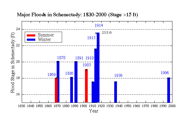
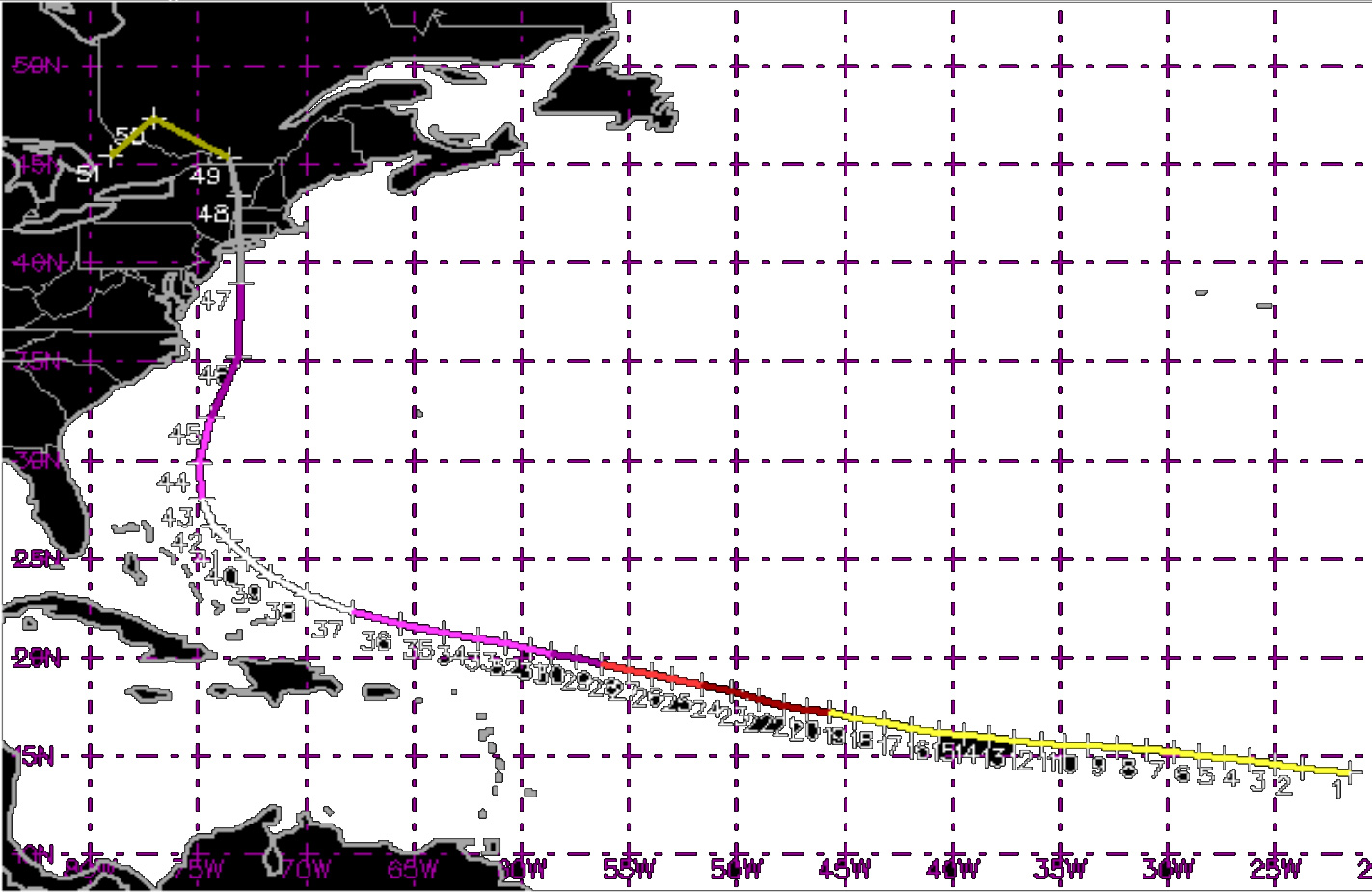
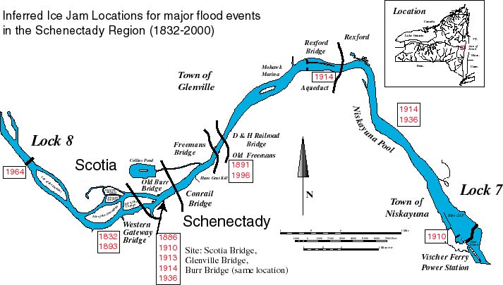
Funded, in part, by the National Science Foundation

© Geology Department, Union College, Schenectady N.Y. 12308-3107.
© Environmental Science and Policy Program, Union College, Schenectady N.Y. 12308-3107. All rights reserved. No part of the document can be copied and/or redistributed, electronically or otherwise, without written permission from the Director of the Environmental Studies Program, Union College, Schenectady NY, 12308-2311, USA.
This document can be located from http://minerva.union.edu/garverj/mohawk