Bridging the Mohawk River
John J. Gara and
John I. Garver, PhD.Geology Department
Union College
Schenectady NY 12308 (USA)
(518)-388-6517Version 2.0 (1996; modified March 2008)
Introduction
The Mohawk River is a waterway that is the trunk line of a 3456 square mile drainage basin in eastern New York State. Historically, it has also been a significant route for trade, migration, transportation, commerce, and industry. Often impeded by ice and obstructions, the 185 billion gallons of water that flow through the Mohawk River's final twenty miles each year offer a formidable challenge. This study focuses on the structures that have been built on the river for all these purposes throughout the river's history. A reflection on the history of bridges, dams, and canals offers insight for future planning as well as an understanding of the challenges that people overcame to make the river a working asset and less an obstacle. This river has a past that was unforgiving toward those who underestimated its power and destructive potential. Therefore, lessons of history must be heeded by those who wish to build in the future.
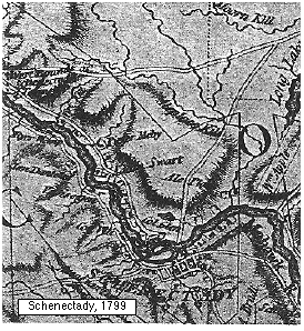
Figure 1 - Historic map of the Schenectady Area
The Mohawk River Valley has had a significant impact on the history of the eastern New York region. It has always been very important to the region for transportation, recreation and as a natural resource. The Mohawk has assisted transportation for centuries, partly because its valley is part of the only flat land route to the nation's interior north of the present-day state of Georgia.
In pre-colonial times, the area now known as Schenectady was S'coun-ho-ha, or "The Door" to the Mohawk tribe that lived there. Metaphorically, this was the eastern entrance to the Iroquois "Long house", their territory that stretched from the Hudson River to the Finger Lakes. It was proper, at the time, to enter the region from "the door" to trade with the Iroquois. In fact, when the French first came to the Iroquois Confederacy from the north in the 1680's, they were confused when Iroquois inquired why they came "from the chimney instead of the door". (Many Mohawk Moons by C.E.Bennett, 1938)
Geographically, this area was important to the Iroquois because the Mohawk was navigable by canoe from Schenectady to Rome with an easy portage around any obstacles. However, downstream from Schenectady travel was difficult and the trip included several falls including a staircase falls at Rexford and a very large waterfall at Cohoes. Altogether, from Schenectady to the Hudson, the river dropped over 200 feet in 15 miles making navigation difficult.
The Dutch moved into the Albany area in 1614, setting up Rensselaerwick in 1624. The Mohawks shifted westward to the Fort Hunter area near present day Amsterdam and the area around present day Schenectady became S'gaun-hac-tac-tic .... "without the door". This may have evolved into the name "Schenectady," which was just a Dutch attempt at pronouncing this native term (Little Journeys Along the Old Mohawk Turnpike, Coughnawaga Chapter, Fonda, NY, D.A.R., 1923). Fur trade between the natives and the Dutch settlers flourished. The prominent Dutchman Arent Van Curler started a settlement in the old Mohawk site as a base for fur trappers in the Mohawk Valley. Schenectady grew to a stockaded village and served as the portage point from the Mohawk to Fort Orange (Albany) through the pine barrens (now Colonie). In 1690, 96 Mohawk Indians and 114 Frenchman commanded by Le Moyne de Sainte Helene burned and massacred the Schenectady stockade at the beginning of the French and Indian conflicts. The village was soon rebuilt. Schenectady's oldest houses, Brouwer House on Church Street and Yates House on Union Street, were both built in 1700 and still stand in the Stockade District of Schenectady (Guide to Historic Schenectady, 1998).
The tremendous discharge of the Mohawk River and its powerful ice breakups in the spring thwarted efforts to bridge the river in its early history. Various communities along the Mohawk started ferry crossings as the area began to flourish. An important crossing was the one from the Stockade to what is now the Village of Scotia, where a cable ferry once operated. This site would be the site of the first serious effort to bridge the river. Theodore Burr, a cousin to Aaron Burr, envisioned a suspension bridge at this relatively narrow point. Work began in the winter of 1794-95 to build a wooden cable on the ice and lift it onto piers before ice-out. Unfortunately, a thaw opened the river and destroyed the work. If successful, it would have been the first long bridge in the 13 colonies. The first bridge over the Mohawk was completed in 1795 between Cohoes and Waterford, a wooden bridge on stone pillars spaced 25-30 feet apart.
In 1804, the state issued a permit for a "rolling dam" to be built at the top of the Rexford staircase waterfall to run a saw mill for the Alexander family. Alexander built the dam in 1805 and then a bridge in 1806, 50 yards upstream from the dam. The bridge connected the Niskayuna area to the Ballston Turnpike to the north. Unfortunately, both structures were lost to ice jam floods that very winter (History of Niskayuna, 1976).
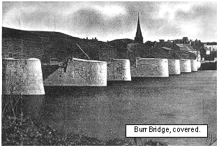
Figure 2 - The Burr bridge, linking Schenectady and Scotia. A wooden, covered bridge.
In 1806, construction began on the Burr Bridge again only to have more setbacks due to ice. Again, workers took advantage of the frozen river only to have their pier scaffolding destroyed when the river ice opened up in mid-winter. Finally, in 1808 the wooden cabled suspension bridge (Figure 3) was finally completed and the river between Schenectady and Scotia was spanned.. The bridge was built with a continuous aspen wood cable that was propped up on stone piers in three places. The deck began to sag between the piers, so four more piers were constructed to fix this problem. This support system resulted in a wavy surface not unlike a modern roller coaster. Later, in 1830, to protect the cables from the elements, the bridge was covered....this is the common image of the structure (see Figure 2).
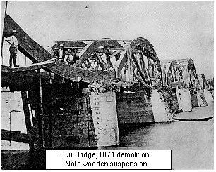
Figure 3 - Burr Bridge in 1871, during demolition.In 1815, boats called "Durham Packets" routinely traversed the Mohawk from Schenectady to Utica. A one way trip averaged 13 hours. To facilitate transport, Governor Dewitt Clinton proposed to build the Erie Canal, or "Clinton's Ditch," in 1825 to connect the Hudson River to the Great Lakes. At that time, transportation by road cost as much as thirty times more than flat water canal transport. Following the success of the Erie, President John Quincy Adams began construction of the Chesapeake & Ohio Canal on July 4 1828 through the Cumberland Gap at a cost of $14 million, the 1828 equivalent to the Apollo Moon Project (Automobile Magazine, 1998)
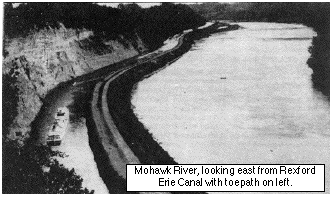
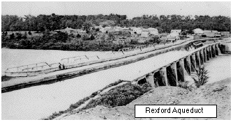
Figure 4 - Erie canal near Rexford.The first phase of the Erie Canal was dug 40 feet wide (28 feet wide at the base) and 4 feet deep with a mule towpath along the sides (Figure 4). In 1825, the Erie had the distinction of being the longest artificial waterway in the world. It was 360 miles long and was traversed by 300 bridges and viaducts. Twenty-two locks lowered ships from 208 feet at Schenectady to sea level at Albany on the Hudson River. The Cohoes "Sixteens" raised boats 140 feet in a staircase of locks. In the Schenectady area, the course of the canal was affected by politics more than by geography and geology. The canal was placed on the Saratoga County side of the Mohawk from Rexford to Crescent to appease orchard farmers, the brick factories, and the timber industry which apparently had a strong lobby. To shift the canal to the Saratoga side, the canal had to bridge to the north side of the Mohawk River at Rexford and back to the south side of the Mohawk River at Crescent. These crossings were accomplished by the construction of two different "aqueducts" which carried the canal and its water over the Mohawk River, the 1160 foot Rexford Aqueduct (Figure 5) and 1840 foot Crescent aqueduct. The Crescent Aqueduct had 26 arched piers and was the longest structure of its kind in the world at the time. The Rexford crossing had 14 piers, several of which are still present today.
Figure 5 - Erie canal as it crossed the Mohawk at Rexford.
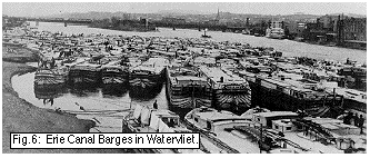
The geography of the Mohawk's waterfalls indirectly drove the nation's first railroad by forcing a faster, more efficient way to bypass the falls between Schenectady and the Hudson River. With twenty-two locks needed to pass all the falls and drop 208' in elevation, travel through this section of the Erie Canal was excruciatingly slow. It generally took a full day to traverse these locks, with most of the time spent going through the Cohoes Falls "Sixteens" for the final descent of 140 feet to the Hudson. Most of the passenger and mail traffic did not go through the 22 lock bottleneck (Figure 6). This traffic got on and off the barges as the canal passed through the Schenectady business district, utilizing the stagecoach between Albany and Schenectady. The stagecoach road went through the pine barrens between Albany and Schenectady. The sands of this route made for difficult travel. In 1831, George Featherstonehaugh made travel more efficient by completing America's first railroad which served this stagecoach route through the sandy pine barrens. On August 9, 1831, the steam train Dewitt Clinton went on its first trip and history was made.
Figure 6 - Barges in Watervliet.
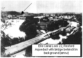
In phase two of the canal, the Erie was widened to 70' and deepened to 9' in 1835 with some rerouting in Vischer's Ferry. In 1841, the locks were doubled, side by side, to handle more traffic (Figure 7). Initially, the new double locks leaked in what was called quicksand at the time. If one side was filled, the other side began to fill, too. The leakage was solved by sealing the bottom of the locks with concrete (History of Niskayuna). The Rexford Aqueduct locks (21 & 22) raised boats 42 feet and this became a popular local tavern site for boatmen waiting for their boats to get through the two locks while they had "just enough time for a couple of tankards of ale." After a full day of poking through 22 locks, this was a well deserved break beforeheading west and picking up passengers in Schenectady.
Figure 7 - Lock 22 at Rexford.
In 1841, a train repair facility was built to service the new trains. Under the leadership of George Westinghouse, and Schenectady's Ellis Family, this facility eventually became the American Locomotive Company in 1845. The rail yards were adjacent to the canal for easy access to iron, wood and other raw materials transported in by barge to run the factories.
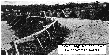
In 1850, a need for a horse and pedestrian bridge across the Mohawk River, northeast of Schenectady, was satisfied with the construction of the private toll bridge at Rexford on the upstream side of the aqueduct (Figure 8). One hundred yards upstream, there was a feeder dam that supplied water to the Erie Canal from lock 21 to Cohoes. On the north side of the river, the canal followed the river's edge, the two waterways separated by a dike which served as a towpath. In 1854, the feeder dam was destroyed by a spring freshet and ice jam. The dam would be destroyed or damaged every year hence for the next 11 years until the state built a stone dam in 1865. A fishway was added in 1884 to help migrating fish species get passed the dam (Canal Society of NYS 1988 field trip guide).
Figure 8 - Rexford Bridge.
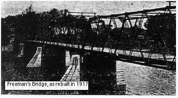
As more crossings were needed and commercial traffic increased, Volnay Freeman built a bridge downstream from the Burr Bridge in 1855. The Burr Bridge was getting very unstable at this point and people wanted an alternative. Freeman built an open wood decked pedestrian and bike bridge that would later accommodate trolley cars. This bridge was first washed out in the ice breakup flood of 3/16/1865. Freeman rebuilt the bridge and it was washed out or replaced due to rot 2 to 3 more times in the next forty-nine years (Figure 9).
Figure 9 - Freeman's Bridge (1917)
The original Burr Bridge, the wooden suspension bridge, was dismantled and replaced with a new iron bridge in 1871 to 1874 (Figure 10). Historically, this replacement is referred to as the Glenville Bridge or the Washington Avenue Bridge. The new iron bridge was placed on the piers of its wooden predecessor. The wood of the Burr Bridge was still sound and was used for homes and barns in the area. The rest went to a match manufacturer. In 1879, the town of Glenville bought Freeman's Bridge to collect the tolls for the town.
Figure 10 - The iron version of the Burr Bridge (1871)
1886 brought the Edison Machine Works to some abandoned railroad shops in Schenectady's South End. Edison Machine Works was to become Edison General Electric in 1889, shortened to General Electric on 1892. This factory of Thomas Edison's would eventually transform Schenectady to the "city that lights the world" or "the Electric City". The location on the Erie Canal and on the New York Central Railroad line was ideal for Edison's growing company.
In 1898, the state built another dam 100 yards upstream from the Rexford Bridge. As with many crossings at this site, this dam had the misfortune of being washed out the following spring, 1899. Five miles downstream from Rexford, the Vischer's built a 790' toll bridge for wagons, horses and pedestrians in 1900 at the site of their ferry crossing. Called the Vischer's Ferry Bridge, this, too, was built only to be washed away in an ice jam flood in 1902. The end piers still exist and a barge hit one of the unremoved submerged piers in 1979.
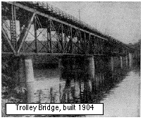
Figure 11 - The Schenectady-Saratoga Trolley bridge (over the Mohawk).
"The Trolley Bridge" was built and opened July 1, 1904 by the Schenectady Rail Company and American Bridge Co (Figure 11). It was built upstream from the Rexford Bridge in Alplaus to give trolleys an express route to Saratoga County from Niskayuna. It was 1800' long with a high steel trestle on top of limestone piers and was the "longest trolley bridge in the world". It served as a trolley crossing to the Rexford/Luna Amusement Park where people could go for carnival rides and the roller coaster (1901-1933).
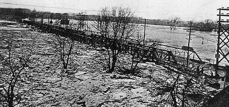
Figure 12 - Flood of 1914 and ice jams.
March 28, 1914 brought one of the most destructive flooding events possible. A heavy thaw followed a 32" blizzard earlier in the week (probably a Nor'easter). The sudden surge of meltwater into a frozen river resulted in ice jams (Figure 12) that destroyed every bridge principally designated for pedestrians, cars & wagons (except for the steel Burr Bridge) for a 56 mile stretch, from Waterford to Palentine Bridge. In the study area, the Freeman's Bridge was the first to be destroyed. Witnesses stated that the ice caught under the bridge and began to lift the steel off of the piers with an audible groan. Two men crossing the bridge went under the ice with the decking and died (Schenectady Gazette). The ice spared the Burr Bridge, the New York Central RR Bridge and the Alplaus Trolley Bridge, the Burr being the only bridge meant for non-rail traffic. The ice flow continued to the Rexford Aqueduct where it destroyed the road bridge next to the aqueduct. Downstream, all other bridges other than the Crescent Aqueduct were destroyed as far as Cohoes Falls.
After the 1914 flood, the building of the Barge Canal was underway, having started in 1905 in Waterford. New replacement bridges were planned based on the river channel changes proposed for the new canal that would utilize the Mohawk River's main channel instead of paralleling the river as the original Erie Canal did. The new Freeman's Bridge was opened in 1917 (see figure 9). The new bridge was a "through truss type" with a wooden deck for pedestrians, bicycles and wagons. It would remain in use for 71 years, outlasting the Western Gateway bridge built in 1926 (Mohawk Sun Paper, 1978).
In 1917, the flow of the Mohawk was changed by the installation of several dams with locks to make the river into a flat water canal. A new route for the canal was made through Waterford with a series of five locks that raised barges 170 feet from the federal dam (Lock 1) on the Hudson River to 185 feet mean sea level (msl) at the Crescent Dam, the greatest rise for lift locks in the world at the time (Hudson-Mohawk Gateway, Thomas Phelan, 1985). This route replaced the 16 lock system on the Cohoes side of the old Erie Canal. Lock 7 and the Vischer's Ferry Dam were built in the Niskayuna/Vischer's Ferry region, raising the water to the 211 foot level. This dam permanently raised the water level at the Schenectady-Scotia area by 3 feet and the Niskayuna area 26 feet. The reservoir inundated the Rexford Falls and the former Erie Canal from Rexford to the new Lock 7 at the dam. These changes in river morphology probably have had the greatest impact on river hydrology since colonization.
Figure 13
The Vischer's Ferry Dam was built in alternate sections first (Figure 13) and then the gaps were filled in. To open a channel for barges, the bedrock from Alplaus to the state dam at the Rexford Aqueduct was removed by dynamite drill dredging by the American Pipe and Construction Company. The rock and dredgings were used to build an artificial island as a diversion breakwater west of the Rexford Aqueduct. Before the Barge Canal could open, the Rexford & Crescent Aqueducts had to be taken down to allow barges through. The center spans were dismantled and a new cantilever bridge was built to span the remaining piers of the aqueduct. The new road bridge at Rexford was opened in 1919.
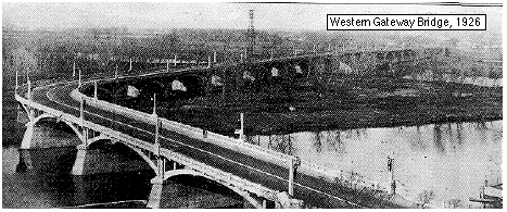
In 1922, construction began on a new bridge that would replace the Burr Bridge which had become dangerous and narrow for the combination of automobile, truck and trolley traffic that was sharing it at the time. The new Western Gateway Bridge, dedicated to Schenectady area's original Mohawk Indian moniker, would be made of concrete. It had twenty four spans, each over ninety feet long, the longest being 212 feet. On September 17, 1923, collapse of the final span which was under construction killed four workers (Original dedication pamphlet, Schenectady County Historical Society).
Figure 14
1924 brought another bridge for cars at Lock 9 ten miles upstream from the Western Gateway, ending service for the Hoffman's Landing Ferry on the Mohawk. 1926 marked the condemnation of the Burr Bridge to Glenville as the $2.5 million Western Gateway Bridge was dedicated on 6/16/26, a year after the first cars began crossing its 4515' span. The Burr Bridge was finally removed in 1939 and the deck of the Freeman's Bridge was replaced with steel in 1940. The piers for the Burr were not removed until 1947, and today the end piers still exist.
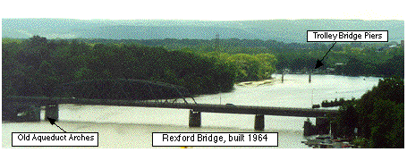
The Trolley Bridge at Alplaus met its demise on December 7, 1941, just two hours before the attack on Pearl Harbor. The steel of the bridge was removed in 1942 for war materials ... "the steel went to war". The center piers were removed several years later (Fig.15) to widen the barge channel (Schenectady Gazette, 9/8/97 by Larry Hart; Figure 11: Gazette 8/30/58).
Figure 15 - Rexford bridge, looking west.
Modernization of the Schenectady bridge crossings began in 1964 when a new Rexford Bridge (Figure 15) was built upstream from the Aqueduct Bridge. Route 146 was rerouted through and demolished what was the McLane's Hotel, a legendary pub on the old Erie Canal at Locks 21 and 22. More aqueduct piers were removed after the forty five year old bridge was removed in May of 1967. Only a couple of arches remain as an historic site of the Erie Canal era. Four years later in 1971, the Western Gateway Bridge was replaced with a girder style bridge with five lane widths, sidewalks and bike paths east of the 45 year old concrete bridge. The Binne Kill branch of the Mohawk was filled in (now parking for Schenectady Community College) so that the bridge would only have to span 1875 feet with the rest of the roadway on an earthen dike. Other significant bridges added were the Twin Bridges of the Adirondack Northway (I-87) built in 1964 and a new Crescent Bridge on U.S. 9. The Twin Bridges are double arched suspension bridges which have no piers in the river channel as they would have been a problem for ice in that narrow section of the river. The Crescent Bridge built right after I-87 opened was a twin arched girder bridge, completely re-decked again in 1996-97 with all new steel girders.
Figure 16
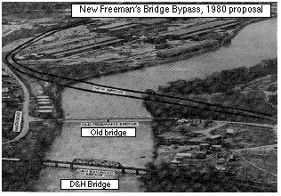
The Freeman's Bridge, dangerously narrow for modern traffic, was proposed for replacement with a girder bridge in 1980. Construction was from 1982 to 1985 with rerouting upstream running diagonally and directly into Erie Boulevard, the site of the old Erie Canal (Figure 16). In 1985, the new multilaned bridge opened to a five lane highway, a welcome change to the two ten foot lanes it replaced. Today, a proposal is being considered to build yet another Rexford Bridge to alleviate the congestion that the two lane bridge causes, though the current bridge is still sound.
The final chapter in the bridge saga is the newest bridge that opened October 21, 1998, fifty years after it was first conceived (Times Union). A new Rotterdam Junction - Glenville bridge has been built to connect the Thruway and I-890 to Route 5 in Glenville about four miles upstream from the Western Gateway Bridge atSchenectady.
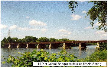
Figure 17 - Conrail bridge in Schenectady.
This completes the brief chronology of bridge crossings on the Mohawk River and it seems clear that bridging the Mohawk has not always been an easy task. Even today, some bridges interfere with the free flow of the river, especially in ice flow season. Future bridge planning must take into account the need for a more efficient flow for winter ice and spring floods. If the frequency of floods and ice jams were to increase, unnecessary obstructions such as the abandoned piers of the Trolley Bridge, the 10 piers of the Conrail (old NY Central) Bridge (Figure 17), or submerged remnants of long removed piers like those at Vischer Ferry, will all take their toll when they restrict the flow of ice in the spring causing unnecessary high water levels.

Funded, in part, by Union College.
![]()
© Geology Department, Union College, Schenectady N.Y. 12308-3107.
© Environmental Science and Policy Program, Union College, Schenectady N.Y. 12308-3107. All rights reserved. No part of the document can be copied and/or redistributed, electronically or otherwise, without written permission from the Director of the Environmental Studies Program, Union College, Schenectady NY, 12308-2311, USA.
This document can be located from http://minerva.union.edu/garverj/mohawk