THE GEOLOGICAL EVOLUTION OF COLLINS LAKE, SCOTIA, NEW YORK, AS REVEALED FROM SUB-BOTTOM PROFILES AND SEDIMENT CORE ANALYSIS (New York)
Kathleen M. Ruggiero
Donald T. Rodbell
John I. Garver
Geology Department
Union College
Schenectady NY 12308 (USA)
(518)-388-6517
Version 1.1 November 2000; modified 2008
Suggested Citation: Ruggerio, K.M., 1999. The Geological evolution of Collins Lake, Scotia NY as revealed from sub-bottom profiles and sediment core analysis: unpublished BSc Thesis, Union College, Schenectady NY. 55 p.
Abstract
Collins Lake is a small oval-shaped lake, located on the floodplain of the Mohawk River in the Village of Scotia, New York. The origin of the Lake is unknown and there are three popular hypotheses that attempt to explain it; a plunge pool, a kettle lake, and an oxbow lake. Many previous studies have been conducted on Collins Lake, but none to determine its origin. This study involves the use of seismic equipment and sediment cores. A sub-bottom profiler, which reveals sediment layers using sonar, was used to take several transects of the Lake and of the Mohawk River. Two sediment cores were also taken from Collins Lake, one in the deep hole, the other a shallower section. A core from a previous study (Allison, 1995), which has a radiocarbon date, was correlated to the two new cores to determine sedimentation rates and an estimate of the age of the lake. Based on the correlated radiocarbon date, sedimentation rates in the shallow core are ~550 mm/100 years, dating the lake at ~820 years old. In the deep core, sedimentation rates are ~660 mm/100 years, dating the lake at ~868 years old. A reasonable estimation is to say that the lake formed ~850 years BP. Grain size and magnetic susceptibility data were also analyzed and correlated to layers revealed by the sub-bottom profiler. The correlating layers, grain size data, magnetic data, as well as, the estimated age of the lake, the proximity to the river and the elevation differences all support that Collins Lake is an oxbow lake, formed by the relatively recent avulsion of the Mohawk River.
IntroductionBackground. Lakes are, on the scale of human life spans, permanent features of landscapes, but on geologic time scales, they are transitory (Hutchinson, 1957). The distribution of lakes throughout the world shows that the events that created them did not act simultaneously and to an equal extent on all lands (Hutchinson, 1957). There are many different types of events that produce lakes, such as, glaciers, fluvial systems, tectonic activity, and volcanoes. In the northeast of the United States, glaciers were an important landscaping feature during the Pleistocene. In the Adirondack region alone, there are estimated to be over 2000 lakes and ponds, mostly of glacial origin (Thornbury, 1965). Glaciers form many types of lakes by different processes. In the upper section of many glaciated valleys, glacial erosion has formed amphitheater-shaped basins, which are referred to as cirques. The lakes that form within these depressions are called cirque lakes (Wetzel, 1975). The lakes are generally fed by runoff from nearby slopes and are dammed by a rock lip above the depression or a small moraine. Some glacial lakes are formed by the deposition of glacial till and debris, these are termed moraine-dammed lakes. In this case, a lake is dammed by a moraine and fills a depression left by the glacier or an irregular deposit of drift.
A very common process of lake formation, which accounts for the origin of thousands of small lakes in North America, is buried ice during meltwater outwash (Wetzel, 1975). During deglaciation, when melting was rapid, large amounts of glacial material were waterborne and carried away from the receding glacier (Fig. 1). In the material were masses of ice, basically icebergs, which became grounded and covered by outwash (Hutchinson, 1957). It can take as long as several hundred years for the ice to melt, and the resultant depression is called a kettle lake. Kettle lakes are commonly irregular in shape, size, and slope corresponding to the irregularities of the ice block (Wetzel, 1975).
The action of running water also has the ability to create lakes. Fluvial systems can create a variety of lakes, for example, oxbow lakes and channel cutoff lakes. It is natural for rivers to meander through valleys. As their sinuosity increases, deposition along the bed and erosion of banks promotes avulsions that isolate sections of a river (Ritter, 1978). An abandoned meander bend forms an oxbow lake (Engeln, 1942)(Fig.2). Variations in topography or even processes similar to oxbow lake formation create channel cutoffs. The cutoff channel forms abandoned channel lakes, which can often resemble a paleostream.
A local, modern example is Ballston Lake, in Burnt Hills, New York, which is hypothesized to be a paleochannel of the Mohawk River (Wall and LaFleur, 1995).Tectonic lakes are created by the movement of the earth’s crust and are therefore limited to tectonically active places. Tectonic basins form as the result of faulting in which depressions occur between a single fault displacement or downfaulted troughs, more commonly called grabens (Wetzel, 1975). A graben is an elongated depression that is bounded by normal faults. As a result, a lake forms in the depression of the newly formed tectonic basin. An example of this is the east African lakes system. Volcanic lakes, like tectonic lakes, are also limited to certain places. Volcanoes can commonly form lake basins by the subsidence of the roof of a partially emptied magmatic chamber or when the underlying magma has been ejected to create a cavity. Accordingly, a lake forms in the remaining void. In many cases, an impermeable clay seal is produced upon eruption by the decomposition of certain materials. The impermeable seal allows the lake to occupy the depression permanently once the volcano is extinct (Hutchinson, 1957). An impressive example of a volcanic lake is Crater Lake in Oregon, which has a depth of over 600 meters (Wetzel, 1975).
Based on the knowledge of the region where the lake formed and the general geomorphology of the lake, it is possible to determine the process that formed the lake based on the nature of the sediment in the lake. Studying the sediment in the lake can usually reveal some distinguishing characteristics. For example, cirque lakes and moraine-dammed lakes commonly have drop stones and varves, which are seasonal laminations of sediment deposited in a standing body of water. When in contact with the ice, the sedimentation rate is rapid (>1cm/yr), but when isolated, the sedimentation rate may be slow (<1mm/yr). In kettle lakes the sediment layers may be disrupted near the base and sedimentation rates are generally considered to be moderate to slow (1mm/yr to 1cm/yr) (Lakes and Environmental Change, 1999). Oxbow lakes and abandoned channel lakes both have channel lag at the base, but are otherwise dominated by fine-grained sediment and sedimentation rates are commonly slow to moderate. Tectonic lakes are somewhat different in that they may have no outlet and in this case input would be balanced by evaporation. Sometimes evaporation of water is greater than input, in which case evaporite minerals and carbonates accumulate in the lake. Volcanic lakes generally exhibit tephra, which is materials ejected from a volcano and transported through the air; including dust, ash, pumice, and cinders. Tectonic and volcanic lakes both have slow to moderate sedimentation rates (Lakes and Environmental Change, 1999).
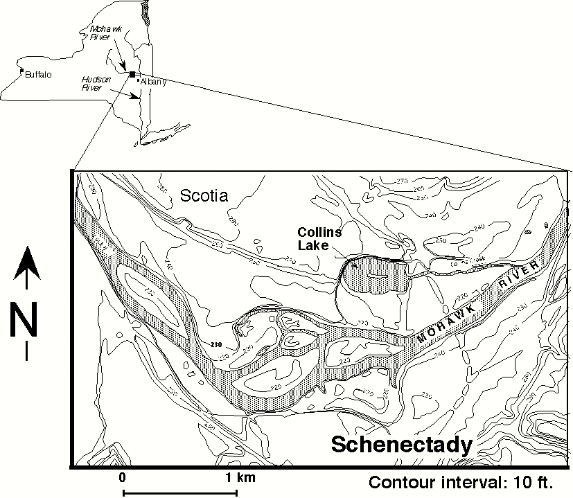
Regional Setting. Collins Lake is a 55 acre, oval-shaped lake located on the Mohawk River floodplain, in the village of Scotia, in Schenectady County, New York (Fig. 3). Collins Park, located next to the lake, is a public recreational area, which includes baseball fields, an ice rink, and a small beach for swimming. The watershed of Collins Lake has an area of approximately 130 acres (Lakes and Environmental Change, 1999). Sunnyside Road borders the lake on the north, Washington Avenue on the east, Ballston Avenue on the west, and Schonowee Avenue on the south side. The deepest part of the lake is in the western section of the lake and reaches about 9 m. The eastern side, which is a flooded marshland area, has depths of about 2 m (Fig. 4). About 400 m to the south of Collins Lake, flowing in an easterly direction, is the Mohawk River. The base of the Mohawk River is 188 feet above sea level, while the bottom of Collins Lake is 181 feet above sea level. Collins Lake is connected to the Mohawk by Collins Creek, which flows from the east end of the Lake into the river. A flapper valve, located at the beginning of Collins Creek, controls the amount of water entering or exiting the lake. On the north and northwest sides of the lake are steep bluffs, which are comprised of well-sorted sands from the Mohawk Delta that formed on the west side of Glacial Lake Albany during the last glaciation (Allison, 1995). The sand, which is very permeable and conducts groundwater, forms a major aquifer, producing springs on the northern shore of the lake. The springs are active all year, which prevents freezing in that section of the Lake (George et. al., 1977). The Nature Conservancy owns the small, elongated island in the center of the lake, which is composed of gravel.
Bedrock Geology. The bedrock geology of Scotia is the Schenectady Formation, which is comprised of alternating shale and sandstone. The formation was deposited during the upper Middle Ordovician Period, about 440 million years ago. During that time period, sea level was much higher than it is today and the sedimentary rocks were formed underwater. The sediment was deposited in a basin, along lateral fans of a sub-marine fan, formed by a sinking foreland basin in front of the rising Green Mountains to the east (Ruedemann, 1930). Measured paleocurrent data from previous studies suggest that the sediment source was to the east, explaining why the shale and sandstone are thinner farther to the west. The Potsdam Sandstone, Theresa Formation, the Little Falls Dolomite, the Amsterdam Limestone, the Glens Falls Limestone, and the Canajoharie Shale all underlie the Schenectady Formation. These formations are well exposed in the Saratoga quadrangle, directly north of the Schenectady quadrangle and these generally dip southwest, which carries them underneath the Schenectady Formation (Ruedemann, 1930).Glacial History. During the last ice age, eastern New York was extensively glaciated. The Laurentide Ice Sheet, which at times was more than 1 to 2 km thick, covered this region. Much of the landscape visible today was strongly influenced by advancing and retreating glaciers, as well as fluvioglacial processes (Fleisher, 1986). As the Laurentide Ice Sheet retreated, at the end of the Wisconsinan Stage, glacial lakes were formed and modern rivers had a much greater volume and velocity. The glacial lake that had most influence on the region including Collins Lake was glacial Lake Albany, which occupied most of the Capital District region (LaFleur, 1965). Late Lake Amsterdam was a deglaciation lake that occupied the eastern Mohawk River. At that stage, the body of water, which was blocked by the Hudson Ice Block on the east, was called Lake Amsterdam. During the stages of late Lake Amsterdam, the Hudson Ice Block reached south past Albany (Fig. 5). Till would have been deposited below what is now Collins Lake, and this, in turn, would be covered by Lake Amsterdam varves. As the Hudson Ice Block began to retreat, glacial Lake Albany formed in response to damming of the Hudson River by large moraines and ice blocks to the south (Fig. 6). Lake Albany received water through rivers, which flowed into the lake and formed large deltas (i.e. Mohawk Delta). Sediment was transported into glacial Lake Albany during this time and evidence of the paleorivers, deltas, and glacial lake are located throughout the region as terraces, foreset beds, and varves. The location of Collins Lake on the delta would have resulted in the Lake Amsterdam varves being covered by foreset beds and fluvial gravels.
The origin of Collins Lake is unknown because there has been considerable glacial and fluvial activity throughout the region. These two processes seem most likely to have been the origin. There are three main hypotheses as to the origin of the lake. The first hypothesis is that Collins Lake is an oxbow lake, which formed as the result of avulsion of the Mohawk River and abandonment of a channel segment, which might have occurred anytime. This hypothesis is supported by the fact that the lake is on the floodplain of the Mohawk River and because the river is so close. Some time after deglaciation the Mohawk may have avulsed forming Collins Lake, which is north of the modern Mohawk River (Fig. 7). If this is how the lake formed, lake sediments would typically be interbedded with flood deposits from the river and would be underlain by a channel lag of the Mohawk, and the oldest lake sediments would effectively date the time of abandonment. The second hypothesis is that the lake is a kettle hole, mainly because the elevation of the bottom of the lake is below the bed of the Mohawk and the deep end is large and nearly circular. The third hypothesis is that the lake formed as a result of a glacial plunge pool. Briefly, when there is a significant gradient during the course of the river, a waterfall may form, resulting in excavation of a basin by the water. Subsequently, the river diverges and a plunge pool lake may form in the deepened basin (Wetzel, 1975).
Historical Accounts. Collins Lake and the surrounding wetlands area were flooded annually by the Mohawk River (George, 1978). In 1804, the lowland between the Mohawk River and Collins Lake was filled, converting that parallel area into the Schonowee Dike, and isolating the lake (George and Welch, 1976). According to George (Personal Communication, 1999) Schonowee in the Mohawk language means ‘the great flats’ and in Dutch it is called ‘Groot Vlachte’ for the Great Flats. In the following year, the Schonowee Dike became a carriage route. Also in 1805, Theodore Burr, brother of the notorious Aaron Burr, built a suspension bridge to provide another carriage route, this one to connect Scotia and Schenectady. The bridge had large masonry, which created ice jams that often flooded the river upstream. Currently, there are just remains of the Burr Bridge. Washington Avenue was built as an extension of the bridge, traveling into Scotia, following Collins Lake along the eastern side. When the bridge was torn down, Schonowee Avenue travelers could no longer cross the river and had to turn left onto Washington Avenue. As a result, both Washington and Schonowee Avenues isolated the lake from the river.
In 1835, the Schonowee Dike was raised about 15 feet above the river and topped with the present Schonowee Avenue (George, 1978). Collins Lake was originally owned by the Glen family and appropriately named Glen’s Lake. Later, it was bought by the Sanders family and named Sanders Lake. Finally, in 1842, Theodore W. Sanders sold the house and property to two brothers, Charles and James Collins (Scotia-Glenville Journal, 1960). The Collins brothers harvested ice from the lake and sold it as “Collins Lake Ice” (Scotia-Glenville Journal, 1964). James Collins died in 1905 and up until that year, the park surrounding the lake had baseball fields, boats, and a dance pavilion. Then in 1924, Collins Memorial Park was created (Scotia-Glenville Journal, 1960). In 1928, the deed to the Collins home and property was given to the Village of Scotia (George, 1978). Mayor William M. Turnbull made an arrangement with the State Waterways Maintenance Department in 1946 to dredge and deepen the channels of the Erie Canal system, which included parts of the Mohawk River (Sunday Gazette, 1997). The State diverted more than one million cubic yards of fill and gravel from the river bottom onto the lower marshland regions of what is presently Collins Park. The gravel was leveled off to a height of 8-15 feet above the marshland, while topsoil from Sander’s land across the road was put on top of the fill (Scotia-Glenville Journal, 1960). The infilling of the lowland region ended agricultural use of that area, commonly broom corn, and promoted recreational use. Also in 1946, a dam and tidal gate, or flapper valve, were constructed at the east side where the lake runs into Collins Creek. The goal of this construction was to prevent the Mohawk from backing up into the lake during flooding (Hartgen Archeological Society, 1987). As a result, the lake level rose about four feet to its current depth and submerged the marshland area in the eastern section of the lake. The dam and flapper valve are not believed to be the only causes for the rise in lake level.
The building of the Vishers Ferry Dam (Lock 7), which was constructed in 1913-1914, 8 miles down the Mohawk River, is also attributed to the lake level rise. The building of a dam downstream may cause water and sediments to back up and raise the water level in the river, and consequently in Collins Creek and Collins Lake (C. George, personal communication, 1999). The Vishers Ferry Dam along with the prolonged development of the Washington Avenue causeway probably contributed to the slow raising of the lake level (George, 1978). Collins Lake was one of the first lakes in the United States that the troublesome water chestnut weed intruded. The water chestnut is an aquatic plant that produces floating leaves and dark spiny fruits, greater than 1 inch (George, 1978). The weed was introduced in 1884 and “appears to thrive only in waters in which the bottom consists of soft mud and where the water level does not fluctuate greatly” (State of NY Conservation Dept., 1934). The water chestnut greatly impeded recreational use of the lake in the early 1900’s because it covered 75% of the lake with floating rosettes, which are impenetrable by boats. Also, the spiny fruits were harmful to swimmers (George, 1978). Curly leafed pondweed was also a problem in Collins Lake.
Both species have to be controlled to continue recreational use of the Lake, which is why restorative dredging was conducted in 1977-1978. The goal of the dredging was to reduce the growth of rooted aquatic vegetation (Enviromed Associates, 1986). The dredging also reduced the nutrient rich sediments and made the lake less eutrophic. As a result, the lake became more suitable for swimming, fishing, boating, and general recreational purposes. The dredged sediments were put in sedimentation basins, which were constructed by building dikes 100 m southeast of the lake (George et. al., 1982).It is generally believed that the water quality of the lake was lowered by snow stockpiling, inflow of street drainage, and adjacent landfilling with river dredge spoils (Enviromed Associates, 1986). The southern shore has often been used as a snow removal storage space, but as the snow melts, lead, oil, and asbestos are leached into the lake (George et. al., 1982). A small sewage treatment plant, located on the northern shore of the Mohawk River at the corner of Schonowee Avenue and Washington Avenue, may also have the potential to lower the water quality of the lake.Previous Studies
Collins Lake is an ideal spot for students and faculty from Union College to study because of its proximity to campus and its many interesting geologic, biologic, and engineering aspects to conduct research on. Kevin Allison completed a thesis in 1995 on the sedimentologic history of Collins Lake (Allison, 1995). In the same year, two more students also did theses on Collins Lake, James Dlubac and Stephanie Howk (Dlubac 1995; Howk, 1995). James Dlubac wrote a thesis on fossil pollen grains and exchangeable metal concentrations. Stephanie Howk wrote a thesis on the frequency of fires based on charcoal in the sediment. Different parameters analyzed from a sediment core were graphed versus depth from information compiled by Allison, Howk, and Dlubac (Fig. 8). Many studies have also been done about the lake dredging, including a few by Carl George, Peter Tobeissen, Phil Snow, and Thomas Jewell, all Union College professors. Hartgen Archeological Associates also monitored the dredging because many historical artifacts have been found. Much research has been done concerning Collins Lake, but in mostly all of the articles and theses, the origin of the lake is stated as unknown, or multiple origins are given. There does not appear to be a solid consensus on the origin of the lake.
MethodsTo measure the thickness of sediment in the bottom of the lake, an Edgetech Geostar Sub-bottom Profiler (SB-424) with Kevlar? reinforced tow cable was used. The system operates at 4-24 kHz. On the boat, there was a topside computer with Intel Pentium II 400 MHz processor, recording data to a 2GB Jazz Drive. In the lab, an EPC GPS-1086 continuous line printer was used. The boat was a 20 foot Starfish 200 Elite Pontoon boat with a 40 hp outboard motor. The surveys were done at speeds between 2-4 knots. A handheld Global Positioning System (GPS) was used for location purposes and the initial depth was found with a Lowrance depth finder. During the Fall of 1998, the newly acquired sub-bottom profiler was loaded onto the Union College Geology/Environmental Studies boat and a survey was taken on Collins Lake. Two trips were made to Collins Lake. A survey was also conducted on the Mohawk River near the remains of the Burr Bridge. During the surveys, the sub-bottom profiler was lowered off the boat into the water at different water depths.
For surface surveys, which reveal the shape of the basin, the ‘fish’ unit was lowered to a water depth of about 1m. However, for bottom surveys, which yield better penetration, the fish was lowered as close to the bottom as possible. Underwater, the profiler emits sonar with a frequency of either 4-16 or 4-24 kHz that resonates off the bottom layers in the lake. The sonar can bounce from the lake bottom to the water surface and back again creating multiples that mimic the water or sediment surface, but do not represent layers in the sediment. Good readings show reflectors, or layers in the sediment.
Several transects were taken across the lake using the sub-bottom profiler (Fig. 9). The transect taken from the beach, north to the center of the bluff reveals interesting layers in the sediment. Another transect was taken from the island, west to the left side of the church, to examine the deep hole from a different angle. In the lab, the computer is connected to a printer, where the profiler readings can be manipulated, for example by changing the lines per inch and gain, and then printed out. At the same time, Lakes and Environmental Change, a course at Union College taught by Professor Rodbell (Geology) and Professor Gremillion (Civil Engineering) during the Winter of 1999, was also conducting studies on Collins Lake. One project of this class was to core Collins Lake. One sediment core was taken from the deep hole to the west of the island and a second core was taken closer to shore (Fig. 9). Other projects included analyzing water chemistry and biological aspects of the lake, as well as taking surface sediment samples from different areas of the lake. Once the lake is cored, layers, grain size analysis, and magnetic susceptibility can be correlated with the reflectors from the sub-bottom profiler readings.
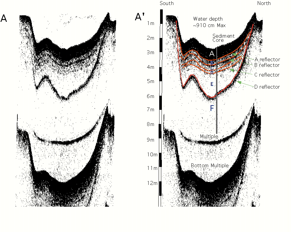
Data In the south to north transect, called A, the dip in the beginning of the transect was caused by increasing the speed of the boat once the fish has been lowered to the appropriate depth. The reading was taken with a gain of 22 and a frequency of 4-24 kHz. In the deepest section, the water depth is 9.15 meters. Several distinct reflectors are seen in the reading, creating different layers (Fig. 10). Reflector A is at the base of the top, surface layer (layer 1), within a meter of the lake bottom. Reflector B is an apparent layer at a depth of about 1 meter in the sediment. Reflectors C and D are within a meter of reflector A, but are not as distinguishable. The most striking layer is reflector E, which is about 3-3.5 meters below the water-sediment interface. Reflectors A-D appear to truncate into reflector E. Two additional lines are revealed, but they appear to be multiples created by the ‘fish’.Another transect was taken in an east-west direction, from the island to the church bluff, called B. This reading was also taken with a gain of 22 and a frequency of 4-24 kHz. Less reflectors and layers are revealed from this transect (Fig. 11). Reflector A is also at the base of the surface layer within a meter of the lake bottom. At about 3 meters down a distinct layer, reflector B, is revealed. Again, a multiple was created at the bottom of the reading.
The Mohawk River transect, taken near the old Burr Bridge, was compared to transect A from Collins Lake, to correlate the depth differences (Fig. 12 & 13). The Mohawk River transect does not reveal reflectors like the lake transect. The water depth in the lake is again 9.15 m in the deep section, while the water depth in the Mohawk varies from 2 m to 7 m. The deep core taken from Collins Lake was 5.71 meters and the shallow core was 4.51 meters. The deep core could not go any deeper into the sediment because of the presence of large cobbles. The sediment recovered is an organic-rich, massive mixture in the top 25 cm. The rest of the core was not massive and contained laminations of sand, silt, and clay. Magnetic susceptibilities (MS) were measured from both cores and compared to each other, as well as to the MS values from Kevin Allison’s 1995 data (Fig. 14). In the deep core there are 4 main peaks in MS (0.85 m, 2.61 m, 4.53 m, and 5.21 m), while there are 3 in the shallow core (1.91 m, 2.60 m, and 4.60 m). Based on the total depth of the cores and the depth of the changes in MS, it appears that 2 of the layers can be correlated. Allison’s core, also taken from the deep hole, has 3 significant increases in MS (0.62 m, 2.60 m, and 4.60 m). One of them is notably close to the changes in MS in our deep core and another is close to a peak in both the shallow and deep cores. A major change in MS occurs at about 2.5 meters in Allison’s core. The change appears to be present in the deep and shallow core also, at about 2.60 meters in the deep core and 1.91 meters in the shallow core. The strata in the core support the peaks in magnetic susceptibility data. In the shallow core the peaks at 1.91 meters and 4.21 meters are pinkish-colored layers in the core. The peak at 3.95 meters is a thin, dark gray layer in the core. In the deep core, the peak at 0.85 meters is dark black organic silt within the grayish-brown sediment of the core. In the core, the second MS peak at 2.61 meters, is marbled red to gray organic silts. A reddish colored silt layer represents the MS peak at 4.53 meters and dark brown-light brown interbedded organic sand/silt layers represent the MS peak at 5.21 meters.
InterpretationProfile A
Both transects of Collins Lake reveal information about the composition of the sediment and the nature of the sediment fill in the basin. In the south to north transect (transect A) the reflectors and layers mark changes in grain size and magnetic susceptibility values. Layer 1 is the top layer from the water-sediment interface to about 0.80 meters. The sediment cores reveal that few layers are present in this layer and it is primarily composed of massive organic matter. At the bottom of the layer, faint layers are present, representing episodic deposition. The peak in MS, from the deep core, at 0.85 meters probably represents the base of layer 1. Layers 2-4 represent about a meter of sediment and can be grouped together because they are characterized by laminations and similar MS values. Layers 5 and 6 are similar because they are without laminae and are separated by the most distinguishing reflector, reflector E, at about 3-3.5 meters. Reflector E is correlated to the significant change in MS values in all three cores. In the deep core, the shallow core, and in the 1995 core (Allison, 1995) the MS change is caused by a difference in sediment composition at about 2.6, 1.91, and 2.5 meters, respectively. At roughly 2.61 meters in the deep core there is a thick layer of predominately sand, which is probably reflector E. The three depths in each of the cores represent the same layer and probably correspond to reflector E. The depth differences between the cores and the seismic profile may be due to sonar attenuation. When sonar is emitted from the sub-bottom profiler it travels faster through water and slightly slower through the sediment, making layers appear deeper then they actually are. Thus, reflector E may appear at 3-3.5 meters in the seismic profile because of the travel time of the sonar through water and sediment, but in fact it may actually be at a depth of about 2.5 meters in the sediment core. The two layers at the bottom of profile A are believed to be multiples. Sonar bouncing off of the ‘fish’ suspended in the water may be the cause of multiple 1. Multiple 2 was probably created by the sonar bouncing off of the sediment surface back up to the air/water surface and then back down to the bottom, which explains why multiple 2 mirrors the shape of the water-sediment interface.
Profile B
In profile B, the east to west transect has a similar profile. Layer 1 is similar to layer 1 in profile A in that it also appears to be massive and about 1 meter below the water-sediment interface. No laminae are present in this layer and, in general, profile B did not yield as many reflectors. Reflector B was the main reflector revealed and is at about 3 meters below the water-sediment interface. It is probably the same as reflector E in profile A. Again, a multiple was created at the bottom of the seismic reading and was probably as a result of the sonar bouncing off of the water-sediment interface. The presence of reflectors and the changes in MS data may correspond to dramatic changes in bulk density and changes in mean grain size. The main change revealed in the sediment core is more sand and silt and less clay. The layers of different density and grain size may be due to the flooding of the Mohawk River.When the Mohawk floods, it overtops its banks and supplies Collins Lake with a significant amount of silt and sand to create such noticeable differences in the sediment. For example, in 1996, the Mohawk River rose 22.7 feet (~7 meters), topped Schonowee Avenue and flooded the Park and Collins Lake. Flooding of the River into the Lake has become less frequent over time due to the formation of Schonowee Avenue and Collins Park. The Lake may also receive river sediments in the winter when ice jams are created on the river and, as a result, water is forced up Collins Creek into the Lake.Elevation Difference It was originally hypothesized that there was considerable elevation difference between the bottom of the Mohawk River and of Collins Lake. The seismic data have revealed that the elevations are significantly different. The Mohawk River is about 211 feet above sea level and Collins Lake is between 210 and 215 feet above sea level.
The Vishers Ferry Dam (Lock 7), which is about 8 miles down the Mohawk, west of Collins Lake, has influenced the height of the Mohawk River. The deepest section in Collins Lake has a water depth of 9.15 meters (29.5 ft) and the sediment core, which was taken from that section, reached a depth of 5.71 meters (18.7 ft). The Mohawk River varies in depth, but the deepest part, as shown from the seismic data, is 7 meters (22.9 ft). However, this part of the Mohawk is kept clear by dredging. When comparing the two seismic profiles (Fig. 12) and analyzing the depth data, the difference in elevation indicates that the Lake is deeper, with a difference of 2-6 meters (6.6-19.7 ft) between the bed of the Mohawk River and the water-sediment interface in the Lake. The difference has a range of four meters because the exact elevation of the Lake is not known, but it is probably closer to 211 feet above sea level. If the depth of the sediment core is figured into the equation, 5.71 meters are added, making the elevation of the ‘bottom’ of the lake 163 feet above sea level. The elevation of the river is not known, but this data support that the Mohawk River has been aggrading significantly since Collins Lake formed.
Hypotheses
The data collected thus far strongly support one of the three hypotheses as to the origin of the Lake. For Collins Lake to have formed as the result of a plunge pool, a significant gradient upstream is required. The gradient produces a waterfall, which excavates out a basin, in which the lake then forms. This hypothesis attempts to explain the deep hole, by excavation from a waterfall, but there is no significant gradient upstream from Collins Lake. All of the surrounding slopes are composed of loose unconsolidated sand, which would be unable to support a waterfall. Therefore, the data do not support that the origin of Collins Lake is a plunge pool.
The second hypothesis attempts to explain the elevation differences between the Mohawk River and Collins Lake. It is hypothesized that Collins is a kettle lake, formed by the deposition of an ice block during glacial retreat, which subsequently melted. Kettle Lakes tend to be deep and irregular shaped basins. Based on the seismic data, the elevation differences between the Lake and the River are not extraordinary enough to support the kettle lake hypothesis, nor is the basins shape significantly irregular. Also, kettle origin would suggest that the lake is ~12,000 years old, having formed after deglaciation, but evidence suggests that the lake is younger. Finally, the data collected support the hypothesis that Collins Lake is an oxbow lake, formed by the avulsion of the Mohawk River. The proximity of the Lake to the River, the flood deposits, as well as seismic data and magnetic susceptibilities all support the hypothesis.
Dating
The radiocarbon date from the 1995 core (Allison, 1995), was correlated to the two new cores to calculate sedimentation rates and give and estimate of the age of the Lake. The sedimentation rates in the shallow core are approximately 550 mm/100 years, which date the lake at 820 years BP. The deep core has sedimentation rates of 660 mm/100 years, which date the lake at 868 years BP. Therefore, a reasonable estimate of the age of Collins Lake is about 850 years BP. The differences in sedimentation rates may be due to the fact that sediment in a lake will tend to settle out into the deeper sections of a lake. The truncating layers revealed in transect A may be attributed to the final formation of the lake. The layers truncate into the main reflector, which is about 2.5 meters below the water-sediment interface and has a correlated date of approximately 200 years ago. Before this reflector, the lake may not have been entirely isolated from the river.
At about 200 years ago, the Schonowee Dike was created, further isolating the lake from the river and the truncating layers indicate closed basin sedimentation. The parameters analyzed in the 1995 core also support changes in the environment at about that time (Fig. 8). Magnetic susceptibility and coarse silt values begin to decrease, as organic carbon, charcoal, lead, and zinc increase. The decrease in MS and silt may be as a result of the Schonowee Dike isolating the lake from the Mohawk River’s frequent floods. The increases in organic carbon, charcoal, lead, and zinc may be as a result of the influence of cultivation, agriculture, and industrialization in that area. If Collins Lake is indeed an oxbow lake, it is then reasonable to assume that the elevation of the bottom of the river should be close to the elevation of the bottom of the lake. If this is the case, then there has been approximately 8 meters of aggradation in the past ~850 years in the Mohawk River, since the formation of Collins Lake (Fig. 13). The aggradation may be due to the building of the locks, which creates elevation differences in the Mohawk River.
Conclusions and DiscussionIn conclusion, the seismic evidence collected, as well as the sediment core, both support the hypothesis that Collins Lake is an oxbow lake. Grain size and magnetic susceptibility data support that the Mohawk River floods strongly influence the influx of sediment to the lake. The seismic data support the differences in grain size and were able to be correlated to a radiocarbon date. The estimated date of the lake further support the oxbow hypothesis, due to the fact that the other two hypotheses would require the lake to be much older.
Future research could include radiocarbon dating materials from the two most recent cores to determine more precise sedimentation rates and age estimations.
AcknowledgementsI would like to thank my two advisors, Professor John Garver and Professor Don Rodbell for their generous time and effort in helping me with my thesis. Many frustrating and cold afternoons were spent on the Lake trying to figure things out. I would also like to thank Professor Carl George for his lending me his time, materials, and knowledge. Special thanks to my fellow thesis-writing geology majors: Mike Sherwood, John McCarthy, Todd Hollenbach, and Pete Castiglia. Without their support and help, this would have been much harder. Finally, I would like to thank my family and Rich Gilooly for their never-ending faith and support.
References
Allison, Kevin P., 1995. The Sedimentologic History of Collins Lake Scotia, NY. Senior Thesis, Union College.Bates, R.L. & Jackson, J.A. 1984. Dictionary of Geological Terms. Anchor Books,
Doubleday, New York.Bennett, M.R. & Glasser, N. F. 1996. Glacial Geology: Ice Sheets and Landforms. John
Wiley & Sons, New York.Chadwick, G.H. 1910. Glacial Lakes of the Catskill Valley. Science 32:27-28.
Cook, J.H. 1924. The Disappearance of the Last Glacial Ice-Sheet from Eastern New York. New York State Museum Bulletin, 251, p. 158-176
Dineen, R.J. 1983. Glacial Retreat in the Hudson Valley Between New Paltz and Schenectady, NY. Geol. Soc. Amer. Abstr. With Programs 15:134.
Dineen, R.J. 1986. Deglaciation of the Hudson Valley Between Hyde Park and Albany, NY. In The Wisconsinan Stage of the First Geological District,
Eastern New York, p. 89-108.Engeln, O.D. von. 1942.Geomorphology. The Macmillan Co., New York.
Fleisher, P.J. 1986. Dead-ice Sinks and Moats: Environments of Stagnant Ice Deposition. Geology, v. 14, p. 39-42.
Fleisher, P.J. 1986. Glacial Geology and Late Wisconsinan Stratigraphy, Upper Susquehanna Drainage Basin, New York. In The Wisconsinan Stage of the First Geological District, Eastern New York, p. 121-142.
Flint, R.F. 1971. Glacial and Quaternary Geology. John Wiley & Sons Inc., New York.
Garner, H.F. The Origin of Landscapes. Oxford University Press, New York.
George, C.J., Tobiessen, P., Snow, P., Jewell, T. The Monitoring of the Restorational Dredging of Collins Lake, Scotia, New York.George, C.J. 1978. The Origin and Early History of Collins Lake.Hutchinson, G. Evelyn. 1957. A Treatise on Limnology. John Wiley & Sons, New York.
LaFleur, R.G. 1979. Deglacial Events in the Eastern Mohawk-Northern Hudson Lowland. In Friedman, G.M., ed., New York State Geological Association.
Guidebook, 51st Annual Meeting, RPI, p. 326-350.Miall, Andrew D. 1978. Fluvial Sedimentology. Canadian Society of Petroleum
Geologists, Calgary, Alberta, Canada.Ruedemann, Rudolf. 1930. Geology of the Capital District. New York State Museum Bulletin.
Schumm,Stanley A. 1977. The Fluvial System. John Wiley & Sons, New York.
Thornbury, William D. 1965. Regional Geomorphology of the United States. John Wiley & Sons, Inc., New York.
Wetzel, Robert G. 1975. Limnology. W.B. Saunders Co., Philadelphia.A Biological Survey of the Mohawk-Hudson Watershed, 1934 by the State of New York Conservation Department
Collins Lake Dredging Program Summary of Cultural Resource Monitoring Through 1994, Village of Scotia, Schenectady County, New York. Prepared by Hartgen Archeological Associates, Inc.
Literature Review of Collins Lake, Scotia, Schenectady, NY, 1987. Prepared by Hartgen Archeological Associates, Inc.
A Guide to Common Waterbirds of Collins Lake. Prepared by Scotia Parks and Recreation-Collins Park.
Sunday Gazette, Sept. 7, 1997. Deal Struck 51 Years Ago Influenced Parks Growth
Engineer’s Report:Continuation of Hydraulic Dredging Program for Collins Lake, Scotia, NY. Prepared by Enviromed Associations, Scotia.
Funded, in part, by the National Science Foundation

© Geology Department, Union College, Schenectady N.Y. 12308-3107.
© Environmental Science and Policy Program, Union College, Schenectady N.Y. 12308-3107. All rights reserved. No part of the document can be copied and/or redistributed, electronically or otherwise, without written permission from the Director of the Environmental Studies Program, Union College, Schenectady NY, 12308-2311, USA.
This document can be located from http://minerva.union.edu/garverj/mohawk