
Albany Airport to Union College
View Larger Map
1. From Airport, turn right onto Albany Shaker Rd/County Rd 151 and go about 1.5 miles.
2. Turn left onto NY-7 W/Troy Schenectady Rd and continue to follow NY-7 W for 4.3 miles.
3. Bear right onto Union St and go 2.7 miles.
4. Turn right onto Seward Pl and go 0.3 mile, almost to the end of Seward Place at Nott Street.
5. Just before reaching the light on Nott Street, at the end of Seward Place, turn right into the Seward Parking lot and park.
total distance: 9.0 miles
total time: 19 minutes
From the South and East: New York State Thruway Exit 25 to Union College
View Larger Map
1. Take Exit 25. Merge onto I-890 W (partial toll) and go 5.1 miles.
2. Take exit 4B toward GE Plant/Erie Blvd.
3. Exit 4B leads to a traffic circle; stay in the same lane as the exit or merge one lane right until you reach Erie Blvd.
4. After about a mile on Erie Blvd, turn right onto Nott St (6th traffic light after entering Erie) and go 0.2 miles.
5. Follow Nott Street through the second traffic light (at Seward Pl) and then take the first right (through a campus gate). Park anywhere in the parking lot on your right.
total distance: 7.4 miles
total time: 13 minutes
From the West: New York State Thruway Exit 26 to Union College
View Larger Map
1. Take Exit 26. Merge onto I-890 east
2. Take exit 4B toward GE Plant/Erie Blvd.
3. Exit 4B leads to a traffic circle; stay in the same lane as the exit or merge one lane right until you reach Erie Blvd.
4. After about a mile on Erie Blvd, turn right onto Nott St (6th traffic light after entering Erie) and go 0.2 miles.
5. Follow Nott Street through the second traffic light (at Seward Pl) and then take the first right (through a campus gate). Park anywhere in the parking lot on your right.
total distance: 7.3 miles
total time: 13 minutes
From the North: I-87 Exit 6 to Union College
View Larger Map
1. Take Exit 6, marked "Route 7 West, Waterveliet/Schenectady".
2. Follow Signs for NY 7W/Schenectady, staying in left lane.
3. Turn right onto Route 7 west from exit ramp.
4. Follow Route 7 west for 6.8 miles and bear right onto Union St.
3. Follow Union St for 2.7 miles.
4. Turn right onto Seward Pl and go 0.3 miles, almost to the end of Seward Place at Nott Street.
5. Just before reaching the light on Nott Street, at the end of Seward Place, turn right into the Seward Parking lot and park.
total distance: 10.8 miles
total time: 20 minutes
Need More Help?
Interact with the locations in Google Maps.
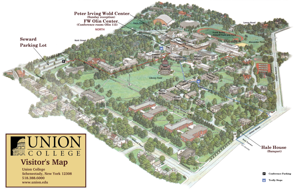
Visitor's Map of the Union College Campus
Some directions and maps provided via Google Maps.